
Surveys
DJC.COM
November 18, 2004
A new tool for analyzing seismic hazards
Special to the Journal
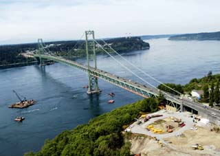
Photos courtesy Shannon & Wilson
A special analysis performed for the new Tacoma Narrows Bridge used results of recent Pacific Northwest seismicity studies.
|
Seattle Fault Zone. Toe Jam Hill Fault. Tacoma Fault. Devils Mountain Fault. Strawberry Point Fault. Utsalady Point Fault. Southern Whidbey Island Fault Zone.
What do these Washington state faults have in common? They are all located in the central Puget Sound region, and until recently, they were either unknown or thought to be inactive. In fact, the locations of some of these faults are very recent discoveries, and the characteristics of these faults are the subject of ongoing research.
New thoughts on local seismicity
In 1992, a team of U.S. Geological Survey scientists reported evidence that the Seattle Fault Zone, thought to be inactive, produced a very large earthquake about 1,100 years ago. This earthquake uplifted the coast of southeastern Bainbridge Island by over 20 feet, generated a tsunami in Puget Sound, and caused numerous landslides from the Olympic Mountains to Lake Washington.
The discovery pace of active crustal faults quickened in 1998 when the use of light detection and ranging (lidar) equipment was introduced locally to map the ground surface for potential earthquake faults. Lidar is similar to radar, except that light waves instead of radio waves are used to create an image of the ground surface.
Field evidence of six major shallow crustal fault systems with historical surface faulting during the last 10,000 years had been found by early summer 2004.

Probabilistic seismic hazard analysis was used in designs for earthquake-proofing the Legislative Building.
|
A tool for seismic design
With our rapidly changing understanding of Puget Sound seismicity, engineers can be hard pressed to estimate earthquake ground motions for design. How can we estimate how strong the ground is expected to shake, given the numerous uncertainties and unknowns about faults in our region? An analysis method known as probabilistic seismic hazard analysis (PSHA) is increasingly being used to answer the question.
The PSHA technique is used to estimate earthquake ground motions that may occur at a site during the design life of a structure, accounting for uncertainty of a random event and lack of knowledge about aspects of relevant earthquake sources.
The steps of the PSHA include:
(1) Characterization of the significant seismic sources in the region in terms of location, fault geometry, maximum magnitude and frequency of occurrence.
(2) An assessment of possible values and relative confidence of each fault characterization parameter.
The information is combined analytically to estimate the average time between occurrences of an earthquake ground motion.
The PSHA technique used to be reserved solely for very large, complex projects such as nuclear facilities or major bridges, as was done for the second Tacoma Narrows Bridge. Using results of recent Pacific Northwest seismicity studies, Shannon & Wilson developed an independent PSHA model to consider uncertainties in potential earthquake location, recurrence, geometry and maximum magnitude for the new bridge.
As computer analysis has become less time consuming and less expensive to perform, PSHA is increasingly being used for typical building projects.
Following the 2001 Nisqually earthquake, questions arose as to whether the earthquake-damaged Washington State Legislative Building would be able to withstand any subsequent earthquake ground motions.
To determine the risk to legislators and staff if they were to reoccupy the building, Shannon & Wilson modified PSHA methodology to answer questions about ground motions in the very near-term. A long-term PSHA was then used to estimate ground motions for design of the seismic upgrade/retrofit of the historic structure. The resultant estimates of ground motion will help preserve the building and provide enhanced safety for its occupants in the years to come.
In places where the understanding of seismicity is rapidly changing or very complex, the use of PSHA provides the best estimate of strong ground motions. PSHA also allows owners, designers and engineers to rationally consider alternative fault characterizations in design.
We are able to estimate ground motions by accounting for and quantifying the uncertainty associated with our changing understanding of Puget Sound seismicity.
Susan Chang, Ph.D., is an engineer with William Perkins; and Robert Mitchell is an engineer with Shannon & Wilson.
Other Stories:
- A new Rx for emergency room design
- Preparing the next design pioneers
- Don't sacrifice green design to 'value engineering'
- How buildings can help 'reforest' a city
- Opportunities abound in China for A/E firms
- What owners need to know about seismic design
- Unique design brings Boeing workers together
- Ready to go national with your design firm?
- A/E firms look to plastic for growth
- Skinner Building gets a seismic skeleton
- Waterlogged walls? New system will tell you
- Designers — beware of technology convergence
- A past blast: building the road to St. Helens
- Commissioning squeezes the best out of buildings
- Peering into the future of urban supermarkets
- Designers have lofty aspirations for housing
Copyright ©2009 Seattle Daily Journal and DJC.COM.
Comments? Questions? Contact us.