
Surveys
DJC.COM
July 25, 2002
Ground zero for groundwater
Aspect Consulting

Herman |
Changes in the land surface and their effect on stormwater runoff and drainage have been important considerations in development for the past decade, and many new models and requirements are used to assist in managing surface water concerns.
Recently, however, the hydrology arguments are being increasingly focused on a hidden component of the water cycle — groundwater.
The increasing focus on groundwater impacts is the result of several factors. Groundwater is the source of water supply for much of the state, and, in light of de facto moratoriums on development of new water sources and the difficulty in obtaining new water supplies, water has become a highly valued commodity.
An even bigger factor is the listing of fish species as endangered or threatened, which has heightened awareness of stream flows in consideration of salmon recovery. Groundwater is considered the most significant contributor to stream flow in late summer and early fall, during prime salmon spawning season.
What does this mean for the developing region? More public focus on real or imagined impacts of development on ground water, and ever increasing requirements for permitting changes in land use. The good news is impacts are often less significant than the conventional wisdom would suggest; and where necessary, mitigation is generally feasible given an adequate understanding of the physical factors involved.
What is groundwater recharge?
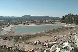
Photo courtesy of Aspect Consulting Land use permits will increasingly emphasize stormwater infiltration and assessment of how that recharge may affect streamflows. |
Groundwater recharge is the fraction of rainwater that infiltrates the ground surface and moves downward to become groundwater. It is one component of the water balance — a mathematical accounting of the water moving into and out of a hydrologic system. With precipitation being the primary source of water, hydrologists use a water balance to estimate the amount of stormwater runoff, evaporation and plant transpiration, with the residual often being the component that moves downward to “recharge” the groundwater system.
The amount of water that recharges the groundwater system is a function of the land cover, soil type and land slope, among other more esoteric factors. Every land use change will change the water balance on some scale, as these factors change in every land development. But such effects need to be considered in the context of the watershed. Is the effect significant and if so, what engineering tools and management practices are available to mitigate the effect?
Heading towards complexity
Water that infiltrates the land surface can travel many pathways because of complex layering of subsurface geology, but eventually most groundwater makes its way to surface water bodies. In the Puget Sound region, many of these are salmon-bearing or potentially salmon-bearing streams. Determining the amount of recharge and the subsurface route of the water are complex, and groundwater hydrologists (hydrogeologists) are the scientists most commonly used to map this pathway.
Some fundamental aspects of groundwater hydrology — namely heterogeneity of subsurface earth materials and the scale of the hydrologic system — place large error bars on the parameters used to describe the groundwater flow system. In addition, the variable nature of precipitation and other weather factors combine to make the most commonly used analyses only generalized estimates, no longer adequate to address potential impacts, in the view of many regulators.
With judicious monitoring and analyses, these generalized estimates can be improved to the level of defensible approximations, suitable for adaptive mitigation.
The hydrology linking groundwater recharge and stream flows is best evaluated on a basin-wide scale. The slower movement of groundwater, the complex layering of subsurface materials, and the tools hydrogeologists have to evaluate the water balance, combine to make the basin-scale the most appropriate level for planning and monitoring. This does not excuse the obvious need to develop land with goals of stormwater infiltration and maintenance of groundwater recharge.
What is important, however, is to understand the level of control needed and to be realistic about the geographic scale of the problem and the monitoring needs.
Some controversy
Just mention impacts to water supply or stream flows and a large constituency will rally against a land use project — in part because it may be difficult to understand the hydrogeologic or “underground” processes, and in part because of the push for salmon recovery. However, there is also genuine controversy among experts and regulators on just how significant the impacts to the groundwater recharge are, particularly given the best management practices required for permitting land use projects today.
On one hand, consider the “one-molecule” standard used by the Department of Ecology in permitting water rights. Under this standard, any withdrawal of groundwater affects streamflow somewhere. Since most rivers do not meet required minimum flows at some time, any reduction in the local groundwater resource could be considered an impact to streamflow. With this standard, it’s not hard to imagine that any land use activity will somehow change the groundwater recharge component, and thus affect a molecule of water reaching the stream.
In reality, impacts of land development on ground water recharge are generally less than is commonly believed, especially with appropriate stormwater management. Basin-scale analysis can generally bracket the level and timing of impacts to be anticipated. In many cases, mitigation to address the “best estimate” impacts is not unduly burdensome. With a credible analysis and well-tailored monitoring plan, mitigation for generalized or “worst-case” impacts should not be necessary.
The new reality
So what are the new realities for land use changes? Not only a strong emphasis on stormwater infiltration, but also assessments of where the water is going in the subsurface, how fast it will get there, and whether impacts to streamflow will occur.
In some cases, development projects are held to performance standards requiring that stormwater be infiltrated in a manner that preserves the pre-development magnitude and timing of the groundwater’s arrival in streams or wetlands. This is a potentially costly requirement that needs careful assessment.
The land use challenge will be to facilitate land development with meaningful hydrogeologic assessments that may extend beyond site boundaries. Appropriate basin-scale analysis combined with realistic mitigation and monitoring should meet regulatory concerns cost-effectively, while simultaneously preserving the aquatic environment.
Lori Herman is a principal hydrogeologist and partner at Aspect Consulting LLC, a specialty practice focused on groundwater hydrology, water resources, environmental restoration and geological engineering. She can be reached at (206) 780-9370 or lherman@aspectconsulting.com.
Other Stories:
- Water storage goes underground
- Getting back to basics with LEED
- Seattle LEEDs the nation in sustainable building
- New stormwater rules looming for contractors
- An incubator for cutting-edge power projects
- Linking up with the environment
- Designers find new life for old cardboard tubes
- EPA turns up the heat with temperature rules
- AGC teams with WSDOT for environment’s sake
- A wholistic look at engineering
- Toxic black mold — the next asbestos?
- Mold: Getting a grip on the fuzzy stuff
- A trail of mining waste turns into a trail of recreation
- No more fuming at chemistry class
- A battery of energy information
- New brownfields law comes with big changes
- ‘Green infrastructure’ puts Seattle on the map
- Detention ponds – all it takes is a little magic
- A pearl of a project on Oyster Creek
- BetterBricks program stacks up energy savings
- Shopping ‘green’
- Home Depot builds atop an old Oregon landfill
- Making clean water the green way
- Salmon in the city: Seattle restores fish habitat
- A funny thing happened on the way to the dump
- Reducing energy costs, post crisis
- Managing stormwater in Pierce County
- Does best available science work for all buffers?
Copyright ©2009 Seattle Daily Journal and DJC.COM.
Comments? Questions? Contact us.