
Surveys
DJC.COM
July 28, 2005
Better mapping may change development rules
Aspect Consulting
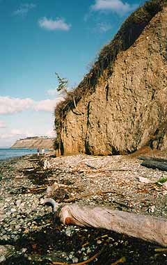
Photo courtesy Aspect Consulting
This unstable bluff on Bainbridge Island is in an area of active erosion.
|
Dramatic improvements in topographic and geologic mapping in the Puget Lowland have increased the ability of scientists and planners to accurately delineate potential geologic hazards.
Geologic hazards have the potential to impact public safety. They include slope stability, volcanic, shoreline erosion and seismic hazards.
Accurate delineation of these areas will allow municipalities to require that developers either avoid these areas, or build in such a manner that the risks are minimized. This article outlines the risks associated with these geologic hazards and offers insights into how development may be affected in these areas.
New tools
Recent development of lidar high-resolution topographic mapping has been a boon to geologists. This technique uses an airborne laser rangefinder that can penetrate dense vegetation and accurately map the ground surface. Much of the Puget Lowland has been flown and the lidar maps show previously unseen topographic features with striking detail.
Another development that has improved geologic hazard delineation is a new generation of geologic maps. GeoMapNW, a geoscience information organization associated with the University of Washington, is actively compiling information on regional soils. With spatial analysis tools, lidar maps, and new soil and rock age dating techniques, GeoMapNW is producing the most detailed geologic maps to date. These maps are essential to improved delineation of geologic hazards, and will be used by planners to determine how and where development should proceed in those areas.
Addressing geologic hazards
The Growth Management Act requires that municipalities protect critical areas and habitat, as well as human life, from geologic hazards. Municipalities deal with geologic hazards by identifying critical areas, establishing land-use regulations, and developing building codes that set construction standards where mitigation of the hazards is deemed reasonable.
Shoreline erosion
Until the late 1990s, permitting of residential shoreline bulkheads was fairly straightforward. An applicant typically needed to demonstrate that beach and upland erosion was occurring and that a bulkhead was necessary to reduce erosion.
In 1999, the chinook salmon was listed as a threatened species and about the same time the state linked adverse impacts to fish populations in Puget Sound to the construction of bulkheads and subsequent loss of shoreline habitat. Bulkhead applications are now reviewed by cities and counties and the Department of Fish and Wildlife. Fish and Wildlife offers its opinion on whether habitat degradation will occur and can recommend to the city or county that the permit be denied, or approved with mitigation.
Mitigation commonly includes beach restoration or artificial nourishment intended to benefit marine habitat. Although Fish and Wildlife's mitigation requirements can be appealed, most applicants agree to reasonable mitigation. In recent years, permits have been granted for repair or replacement of existing bulkheads. Permits for new bulkheads are only issued if the applicant can demonstrate, typically through a geotechnical professional, that a bulkhead is necessary to protect site improvements.
"Soft" shoreline protection uses restrained beach logs and beach nourishment to provide some of the protection of a bulkhead with the mitigating effects of beach nourishment. Soft bank protection is favored and sometimes required by many municipalities before a hard surface bulkhead can be built. However, long-term performance data is limited and the effectiveness of soft protection is highly site specific.
Upland slope stability
A typical approach by a municipality is to require that an applicant build outside of an established critical area setback. Development inside the setback may be feasible provided the applicant can demonstrate the project will not decrease stability or increase risk to adjacent properties.
Prior to 2004, most municipalities used building design requirements based on the Uniform Building Code. Most adopted the more stringent International Building Code in 2004.
A consequence of IBC-based codes is that developers must demonstrate that slopes and structures will remain stable during much larger earthquakes. This does not preclude future development of all these sites, but it does mean that site developers will spend more time and money on slope stability studies, and many sites will require expensive engineering design and higher building costs.
New discoveries
Analysis of lidar images, regional geophysical surveys and field studies have revealed a complex network of faults within the Puget Lowland. Some of these faults are considered active, meaning they could potentially rupture in the future.
These discoveries have recently lead scientists to significantly upgrade the assessment of seismic hazards within the region, resulting in more of the Puget Lowland being classified as high risk. Future study could increase the hazard ratings for some areas and refine the extent of areas that are currently identified as high risk.
The most significant seismic hazard to the region is ground shaking, which is handled with building codes that require new buildings withstand a specific level of shaking. Another newly identified seismic hazard is ground rupture, which is folding or tearing where a fault plane extends to the ground surface. Although generally not required at this time, some municipalities may adopt recommendations or requirements for additional studies in these areas or design mitigation or setbacks from identified active faults. Developers and planners should stay attuned to this rapidly emerging science.
Tsunamis
Tsunamis are now known to have occurred within Puget Sound. While tsunami hazard evaluation in Washington state is in its infancy, the National Oceanographic and Atmospheric Agency and the Washington Department of Natural Resources have modeled the tsunami hazard for a rupture of the Seattle Fault. The studies have not advanced enough to realistically define tsunami hazard areas, however, as the models are improved, tsunami inundation maps may become part of the standard critical areas portfolios for Puget Sound waterfront communities.
Volcanic hazards
The 1980 eruption of Mount St. Helens was a dramatic reminder that we live in an area of volcanic hazards. Despite Mount St. Helen's recent activity, Mount Rainier is considered a much more significant hazard. Geologists have uncovered evidence of gigantic volcanic debris flows called lahars that have flowed from Mount Rainier down valleys as far as Kent and Tacoma.
Although lahars are rare events when measured in human life spans, destruction of communities within their paths is nearly certain. All of the major drainages that flank Mount Rainier are potentially subject to these flows.
The areas subject to lahars are well identified and can easily be avoided, but because it is difficult to assess the risk, there are currently few land-use requirements that limit development in most lahar-prone areas. Volcanologists are working with emergency managers, local governments and citizens groups to develop lahar warning systems. The lahar evacuation signs posted in many areas below the mountain are a reminder of the ever-present risk.
The good news
Our knowledge of geologic hazards within the Puget Lowland is continually evolving. Site developers should expect increasing land-use restrictions around identified hazard areas, new requirements for site-specific studies, and increased time and costs to address these issues. The positive side of these new findings is that this wealth of information now gives us the option to design structures with these hazards in mind, or avoid the high-risk areas entirely.
Dave McCormack is a senior engineering geologist with Aspect Consulting. He specializes in geologic hazards and stratigraphic analysis.
Other Stories:
- Green buildings can spark economic growth
- Whitewater parks move into the mainstream
- Momentum is building to reduce global warming
- Turning waste into environmental, social good
- Let the sunshine in, efficiently
- The hazards of flicking on a light switch
- A road map for Columbia Basin's future
- Canada: A lesson in salmon recovery planning
- What makes a green consumer?
- Farmers, government team up to save fish
- Seattle law firms end their paper chase
- Food industry puts energy efficiency on the menu
- A solution to Hood Canal's lurking pollution?
- Stretching Washington's water supply
- Saving salmon: Now the hard work begins
- Seattle finds gold with sustainable strategies
Copyright ©2009 Seattle Daily Journal and DJC.COM.
Comments? Questions? Contact us.