
Surveys
DJC.COM
April 27, 2006
Using GIS as a tool to protect Puget Sound
Jones & Jones

Overdorf
|
However, the intrinsic landscape formations and features that define each local region are not being recognized. As a consequence, people are not making a connection with their signature landscapes nor discussing how to protect them. This is a serious matter; for it is the connection people have to the landscape that has historically proven to be the synthesis for the environmental movement.
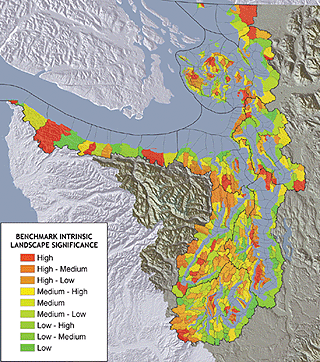
Images courtesy Jones & Jones
GIS analysis of watersheds of the eight regions of Puget Sound.
|
Only by understanding the geography can we identify the inherent features of the landscape. Even this country's earliest planners recognized the role of identifying geographical features as essential to the protection of our most celebrated landscapes.
Natural Bridge, a 215-foot-tall stone bridge in Virginia once considered a natural wonder of the new world, was used by Thomas Jefferson to promote the natural beauty of our country and inspire politicians, writers and artists.
The 1888 plan for the park systems of Minneapolis and St. Paul proposed by H.W.S. Cleveland, a pioneer of American city planning, was based on the identification of landscape formations, such as the ring of glacial pothole lakes in the Minnehaha watershed, that could serve as an armature around which to design the city and shape growth.
O.C. Simonds and Jens Jensen, leading landscape architects of the 20th century, argued that planning will be successful only by understanding, revealing and preserving landscape forms and scenery that reflects the local and regional character of a place.
Missing the intrinsic landscape
While typical scientific analysis of ecosystems helps people understand how the systems behave and which factors contribute to their health, it doesn't give us a complete understanding of regional landscapes' inherent aesthetics.
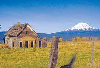
Historic sites and landmarks confer intrinsic cultural significance to a landscape.
|
When analyzing Puget Sound as a whole, many techniques fail to recognize that the Puget Sound basin is a collection of smaller landscapes, each with a unique set of intrinsic landscape features. Many science-based ecological planning models fall short in reflecting the importance of these individual landscapes.
When Puget Sound is further analyzed in terms of its biodiversity, the emphasis is given to the San Juan Islands while the issues faced by other areas, such as the South Sound and Hood Canal, go unrecognized. If we are to truly protect Puget Sound, we need to integrate intrinsic landscape analysis into the equation. Identifying landscape characteristics — which define a subregion's formations of aesthetic significance, such as coves, river mouths, lagoons, spits, peaks, ridges, salt marshes, large sea stacks and sand dunes — helps us protect the quality of our environment.
Interpreting the landscape
Many land trust and conservation groups are realizing the importance that interpreting the intrinsic landscape can add to their land conservation strategies. By identifying these resources — determining which are rare, and how people value them — these organizations can better prioritize their activities. The Trust for Public Land (TPL), a national nonprofit land-conservation organization, has built this approach into its conservation planning.
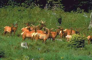
Wildlife viewpoints heighten a landscape’s intrinsic value.
|
"You can do all the science you want, but the only proposal approved is the one whose local delegation is telling their representatives what's important to them," said Roger Hoesterey, TPL Northwest regional director. "If you don't ask the local people what's important to them or why they go somewhere — whether it's to see the view, the beaches, the clams, or the mountain cliffs — you won't get anywhere. Ask them, 'Did you know this is the last sandspit, the biggest lagoon or the highest mountain face in your subregion, and it's got access, but it's not publicly owned?' Turn it into a compelling story with GIS."
Armed with this new strategy, TPL, with the Nature Conservancy and the People for Puget Sound, recently was awarded a $3 million grant from the Russell Family Foundation to launch the Puget Sound Shoreline Strategy. The goal of the project is to raise $80 million to protect hundreds of miles of Puget Sound shoreline and develop 10 new parks and natural areas — all by reconnecting people to the intrinsic qualities of our inland sea.
The Greenprint project
Recently, King County's Department of Natural Resources and Parks, with TPL, Jones & Jones Architects and Landscape Architects, Earth Analytics, and the Point Wilson Group, developed the Greenprint for King County. The purpose of the project was to develop a land acquisition and conservation vision for all of King County.
"The vision articulates the importance of completing an interconnected network of land and water resources for the purposes of fish and wildlife conservation, farmland preservation, working forests, functioning floodplains, and the completion of a premier regional trail network," said Jennifer Knauer, Greenprint for King County project manager for King County DNRP. "It is now possible to efficiently identify functionally valuable open space lands in need of protection, with the assistance of the project's landscape characterization GIS computer model."
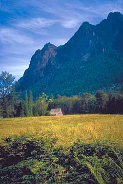
The magnitude of landscape forms contributes to intrinsic value.
|
Most recently, the ecological planning and design projects undertaken by Jones & Jones represent efforts to capture the notion of place and identify intrinsic landscape processes for conservation purposes. In an effort to support the original Greenprint for Puget Sound strategy for TPL, Jones & Jones developed a GIS-based model called ILARIS (Intrinsic Landscape Aesthetic Resource Information System). It is being used on several conservation and stewardship planning projects in our region.
To better protect Puget Sound's scenic and culturally sensitive lands, it is critical that planners catalog the best examples of regional landscape and assist communities in understanding how these rare landscape features fit in their own subregions, as well as in the larger regions and the world.
While we all recognize the importance of aesthetic resources, we, as professional planners, seldom take the time to represent them in GIS or integrate them into our scientific analyses. By measuring and monitoring the intrinsic aesthetic landscapes, so others can see them as a diminishing resource, we can provide community leaders with a more comprehensive form of mapping that supports discussions for conservation of our treasures.
Christopher L. Overdorf, ASLA, APA, is a principal with Jones & Jones Architects and Landscape Architects. He specializes in advanced planning and design technologies, including the integration of GIS with landscape aesthetics.
Other Stories:
- Arsenic-eating ferns may clean up Puget Sound soils
- Is this as green as Seattle gets?
- Putting a forest floor up on the roof at the zoo
- Program catalogs our fading historic landscapes
- Veterans' cemeteries: an inspiration of place
- Creating an urban forest in Anchorage
- Site constrained? That's opportunity knocking
Copyright ©2009 Seattle Daily Journal and DJC.COM.
Comments? Questions? Contact us.