Surveys
DJC.COM
April 17, 2008
Use a site analysis to value rural conservation lands
R.W. Thorpe & Associates

Thorpe
|
Landscape architecture can be an important contributor in the master planning process, especially when using a site analysis.
Historically called carrying capacity analysis — and used for master planning, golf courses, resort communities and emerging forest land communities in timber conversion areas — site analysis provides a basis for the valuation and appraisal of the benefits of conservation trusts and in condemnation proceedings.
Site analysis is fact-based and covers topography, slopes, wetlands, water bodies, wildlife, views, sun angles, geo-tech information and private-sector studies. This approach has been greatly aided in the last few years with the quantum changes in GIS, CADD and other tools. The ability to use different computer platforms and integrate GIS with CADD helps the landscape architect with site planning, carrying capacity studies and most-probable-use analyses.
Why the emphasis on carrying capacity? The passage of the two growth management acts in Washington in the early 1990s placed significant emphasis on critical areas and made “buildable lands area inventories” essential to obtaining development permits.
For lands outside the urban growth boundary, lot sizes can range from five, 10, 40 or even 80 acres. However, decisions from growth hearings boards have indicated that one-, two- and three-acre lots are not “rural.”
Counties use the five-, 10- and 20-acre densities, which results in segregating large sections of land into cookie-cutter lots with intervening roads and individual wells and septic systems. That impacts open space, wildlife, critical areas, safety, and public services such as police and fire.
The cluster alternative
Cluster designs keep 66 percent to 90 percent of the open space while incorporating conservation trusts, development agreements, and covenants, conditions and restrictions. One example is the 25,000-acre Olympic Resources master plan community in Skamania County. It has about 2,800 units on less than 5 percent of the land.
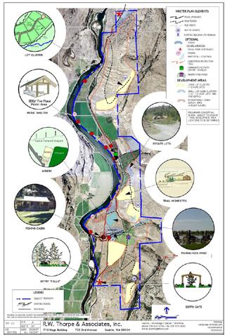
Another example can be found on a 1,000-acre site in Okanogan County that has 65 percent open space and preserves the historical riverfront, apple growing areas, wildlife corridors and unique features such as waterfalls.
Both of these projects included conservation easements with use agreements for agricultural production, wildlife corridors, trails and other features retained by the master plan lot owners.
Conservation trusts
A study team that included appraisers Bill Mundy (who started his company with Robert Thorpe & Associates in 1976) and Vicki Adams worked with owners, attorneys and tax accountants to develop a plan to preserve more than 95 percent of a 6,000-acre property on Squak Creek in Kittitas County.
The property analysis provided for 50-plus high-value building sites by retaining 10 to 12 building sites, with the remainder being conveyed in a “rolling conservation trust” over several years. The beneficiaries of the conservation trust were the Cascade Land Conservancy, National Conservation Trust, the Anthropology and Horticulture departments at Central Washington University, and the Yakama Tribe.
The carrying capacity analysis for the Squak Creek project determined a net lot yield and development cost, discounted against potential lot sales. The site’s highest and best use was determined in order to provide a land value that can be appraised and set up in a program using a tax accountant and attorney to convey to a conservation trust. This provides a tax benefit to the property owners over a period of time.
Timber/agricultural conservation trusts are being used in Washington, as well as throughout the western United States.
Eye-opening visits
I recently visited sites west of Denver — near Jackson Hole, Wyo, and Bozeman and Missoula, Mont. — and found increasing numbers of 5- to 40-acre subdivisions. The net effect of that type of development is more roads, stretched water rights, reduced safety, and negative impacts on views and wildlife.
The key to supporting conservation trusts is to use site analysis and most-probable-use studies. Clients in Jefferson, Thurston, Mason and Kittitas counties developing forest land communities used these tools for proposed cluster developments while retaining natural areas, critical areas, and timber and other natural resource protection areas.
Robert W. Thorpe, AICP, is a land planner/economist who also teaches land economics and permitting at the University of Washington, Bellevue Community College, NAHB, Master Builders, and other Western Washington universities/colleges. He is past president of PSC-American Planning Association, and has practiced in Washington since 1966.
Other Stories:
- Landscape design inspiration beyond the office walls
- Seattle designer has a renaissance in North Dakota
- Easy steps to successful wetland mitigations
- Are meadows the hot new landscape trend?
Copyright ©2009 Seattle Daily Journal and DJC.COM.
Comments? Questions? Contact us.
