DJC.COM
November 19, 2009
Bellevue reconnecting with its waterfront
AECOM

Fischer
|
Imagine the city of Bellevue as one of the Puget Sound region’s premier waterfront cities. Once a bustling waterfront town, the Bellevue has long had a vision of reconnecting to its waterfront.
A new master plan for Meydenbauer Bay, as drafted, would create a vibrant park that strengthens connections between the historic waterfront, the marinas, Main Street in Old Bellevue, Downtown Park and the city’s urban center. Attractive streets, new uses, parks and public spaces would create a remarkable and memorable place on Meydenbauer Bay, restoring Bellevue’s prominence as a waterfront city.
The draft master plan awaits further review and recommendation by the city’s Parks Board prior to adoption by the Bellevue City Council.
For the past 20 years the city has worked to acquire parcels as they have become available to realize a bold vision of re-linking the Bellevue community to its waterfront history. Over the past three years a steering committee, appointed by the Bellevue City Council and representing diverse interests, directed a team of planning and design consultants led by AECOM to prepare a master plan and environmental impact statement for a 9.5-acre waterfront park.
The park master plan, prepared by AECOM in close collaboration with Perteet and Moffat & Nichol, reflects the steering committee’s consensus and recommendations developed through their public planning process.
A restorative place
A key component of AECOM’s master plan rested in understanding the complex history of the site. Located at the Bellevue Marina on Meydenbauer Bay, a historic whaling building remains a testimony that Bellevue was once a working waterfront town. As the city grew more urban, the maritime economy diminished and the city center moved north.
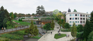
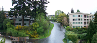
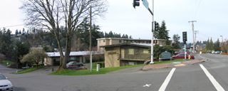
Images by AECOM Park plans call for a terraced structure to accommodate the 80-foot grade change at the site. A community activity building would include an elevator that connects the upper and lower park areas. The photo below shows how the site looks now.
|
|
The new park is envisioned as a restorative place where visitors recreate and reconnect with the historical, natural and cultural landscape. Located downtown, a short stroll from shopping malls, high-rise office towers, upscale residential towers and the city’s original Main Street, the public park will attract visitors of varied interests and ages — serving nearby neighborhoods as well as the broader community.
In addition to improving public access to the water and increasing recreational opportunities, the plan includes several recommendations to restore the site’s ecology.
The master plan proposes to partially remove shoreline structures and restore shoreline vegetation, daylight a creek, reforest the hillside, remove invasive species and reduce overwater shading to improve fish habitat. The plan also recommends sustainable development strategies, including the use of bioswales, permeable pavements, native plants, local building materials and green building technologies.
The steep terrain accommodates stacked uses such as underground parking, buildings tucked into hillsides, and rooftops with overlooks and public spaces.
Gateway to the waterfront
Responding to the unique characteristics of the site, including adjacent uses, views, vegetation and steep slopes, the master plan proposes several distinct use areas connected by a pedestrian promenade that runs parallel to the shoreline. The plan accommodates a vertical grade change of nearly 80 feet, integrating buildings, underground parking, elevators, stairways, bridges and other distinctive site architectural elements.
Visitors may arrive on foot, by car, boat or bicycle. A variety of routes would accommodate people of varying abilities to fully enjoy the site.
One of the most dramatic new places would be the park entry plaza located near the intersection of Main Street, Lake Washington Boulevard Northeast and 100th Avenue. The master plan recommends creating a new urban plaza and memorable connection by removing an apartment complex on a kite-shaped parcel of city-owned land.
The plaza would be a gateway to the waterfront, showcasing art, offering dramatic views of the water and providing a gathering space on Main Street. The structure supports an elevated, stylized pier that terminates in a viewing platform. The plan recommends closing 100th Avenue Southeast to vehicular traffic and building a pedestrian staircase with viewing and seating terraces framed by attractive water and landscaped drainages features.
The historic whaling building would become a centerpiece of the marina district where a proposed reconfiguration of piers and moorage would improve views, accommodate transient moorage, provide education programs and reduce overwater coverage.
The park entry plaza near 100th Avenue and Main Street would offer views of Meydenbauer Bay. The apartment building on the corner (below) would be razed to make way for the project. |
|
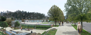
The city-owned residential properties between Meydenbauer Bay Beach Park and 99th Avenue Southeast would be converted to park land. Shoreline activities would include a larger beach, playground, and picnicking and sunbathing terraces.
The swim area is defined by a curvilinear floating pier that also provides moorage for kayaks, canoes and other people-powered vessels. An elevated overlook is planned for land adjacent to Lake Washington Boulevard. A community activity building with parking beneath it abuts the hillside, efficiently uses the land, places required parking out of sight and provides elevator access between the upper and lower park areas.
Hillside trails, rock outcroppings and small outdoor spaces would be used as informal meeting spaces and as opportunities for interpretation of the park’s history and natural resources. An elevated bridge would span the daylighted creek at the west end of the park, providing views of the restoration efforts and connecting to a trail that leads to the existing parking.
Like many other major public projects, the Meydenbauer Bay park and land use plan has gone through an intensive process to balance the needs of the community, neighborhoods and the environment. Some neighbors and adjacent property owners have raised concerns about the impacts of additional pedestrian and vehicular traffic, proposed circulation changes, parking issues as well as potential increases in noise and undesirable activities. In response to these concerns, the city has prepared an environmental impact statement.
Every major public project begins with a vision that drives communities to take bold steps toward change. Such bold steps were required to begin the process of restoring Bellevue as one of Puget Sound region’s premier waterfront cities.
Sandy Fischer is a principal in the Seattle offices of Design + Planning at AECOM.
Other Stories:
- Bellingham embarking on ambitious waterfront plan
- Magnolia Bridge complicates pier project
- Placid park belies a major engineering effort
- 21st-century waterfronts: What makes them work?
- Planning a shoreline project? Win over the public first
- Kennewick island lighthouse a beacon for downtown
Copyright ©2009 Seattle Daily Journal and DJC.COM.
Comments? Questions? Contact us.