|
| |
|
|
GIS hits a home run for the new baseball stadium
By CAROL SANDERS
Timely construction of the new Mariners Stadium requires efficiency, organization, hard work and a bit of luck -- not unlike environmental and aquatic cleanup projects.
Although Sanders & Associates, Inc., (SAI) is known in the consulting engineering field for its work in environmental cleanup on the nation's waterways, Walter/SCI Construction (the main subcontractor to general contractor Hunt-Kiewit) hired our firm to provide field surveying, scheduling and computer-aided drafting services to collect, manage and report complex data for the stadium project.
With aquatic cleanup, the methods for data collection and reporting are extremely complex and must comply with stringent environmental regulations. SAI has applied its knowledge of data management on the stadium project, and the results are astonishing.
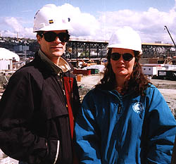
SAI has been involved in the project from initial excavation to erection of the rail track for the retractable roof. Originally Patrick Moore, senior associate of SAI, was involved in providing project scheduling to Walter/SCI. It became apparent early in the project that there would be numerous requests for information (RFIs) as the nature of the job is closer to a design-build.
Since SAI was involved in numerous aspects of data collection and data management on the project, the company decided to incorporate all the data it had been collecting into a special data automation system called a "Geographical Information System" or "GIS."
SAI has used GIS software extensively on many environmental projects throughout the country and is utilizing GIS software to bring together the schedule, as-builds, document/contract databases, and soon, costing elements of the project.
One advantage of using a GIS on this project is that the scheduling maps give everyone involved on the stadium a visualization of where we are heading with the construction and why.
People are used to working with maps and maps provide a more efficient way to convey information than bar charts or PERT charts. In essence, it brings the construction sequence to life. In addition, a GIS is a powerful analytical tool. One can utilize it to analyze data both quantitatively and qualitatively.
Because a GIS system easily integrates other technologies from remote sensing and data base management to GPS, scheduling and document control, it can become the core of an overall data management and analysis system. We believe that GIS will be the vehicle by which most information systems management duties will be performed in the future.
Given the fast-track schedule and logistical complexity of the project, data management is essential. With dozens of subcontractors working to complete the stadium by early July 1999, GIS has proven to be an essential tool.
According to Moore, using GIS for data management provides not only data archival and analysis, but also the ability to visualize the project. Over the last four years in his capacity as an engineer with SAI, Moore has developed GIS databases and applications for ground water, transportation and environmental projects.
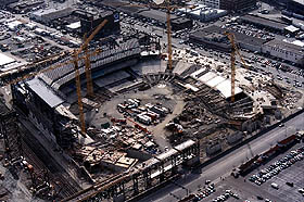
Though large environmental projects generally involve larger geographical areas than the roughly 20 acres involved in the stadium project, the stadium has proven to be very data intensive.
"It really is like building a small city out here," Moore says.
As the GIS developer for the stadium construction, Moore was able to link the scheduling technology software to a GIS.
"We could perform traditional scheduling routines using the scheduling engine and display that in map form to give everyone an indication of where we are going," says Moore. With SAI's scope including scheduling, surveying, layout and shop drawing preparation, the firm had a good idea of the major components of the project, and most of these were integrated into the stadium GIS.
Early in the project, Hunt-Kiewit determined the global issues and drop-dead dates that would drive the schedule. One key issue was that the structural steel needed to be erected for the seating and tracks supporting the retractable roof. The contractor needed to have certain elements of the stadium completed prior to the steel arriving on site.
To support this goal, the GIS system was used to plan what elements could be cast-in-place and what elements could be precast and placed by one or more of the tower cranes. While this was an extremely simple task for GIS, it was a logistical challenge for the contractor.
The advantages of using GIS for these calculations were numerous. If the elements changed, support code developed for the project was run, and the planning map was easily changed. Having a map at your fingertips, immediately after a change was made, was something that got Hunt-Kiewit's attention. This simple application opened the door for using GIS for other types of applications, including document management and as-building.
Applying GIS to construction is a unique application. Many contractors would consider it an overhead expense. Yet most applications devised for the stadium project have added efficiency and substantial cost savings, because computer code used for the analysis for one area could be reused for other areas.
The success is inherent in how GIS is designed. GIS analyzes and maps data. Cities use GIS to help plan and provide better services to taxpayers. McDonald's even utilizes GIS to site new hamburger stands. GIS is a powerful tool for data management and data automation.
Of particular interest to those in the construction industry is the ability of GIS to track job changes and costs. These changes are critical in determining potential cost overruns and scheduling delays. Any changes are added to the GIS system along with specific data regarding the change: the who, what, where and when. Data can then be requested such as, "Give me all of the RFIs for pilecaps pertaining to rebar."
The GIS aids in keeping project participants informed of changes. With over 5,500 RFIs, just mapping the changes is helpful.
In addition to tracking changes, the GIS system is excellent for data retrieval and storage. At various stages of construction, as-built data and digital photos are added to the GIS. This enhances quality assurance during construction and provides for data archival at the project close-out.
GIS is not just suited for mapping and tracking data on a large construction project. It can be used in construction claims for "reconstructing the past" or for small- and medium-size projects. Managing information is at the heart of GIS.
"We just needed to know where we were headed and what we needed to track... and we took it from there, creating a useful planning and document management tool that can be used on many other types of projects," Moore said.
Carol Sanders, P.E., is president of Sanders & Associates, Inc., a Kirkland-based engineering firm.

Copyright © 1998 Seattle Daily Journal of Commerce. |