|
| |
![[design '97]](design97.gif)
|
|
| |
|
|
Portland moves ahead in transit-related development
By JUDY DAVIS The Portland metropolitan area is using light rail as one of its tools for focusing growth, limiting sprawl and retaining a vibrant urban center.
Pushed by the energy crises of the 1970s and a neighborhood revolt against the proposed freeway, the Portland region rethought its automobile dominated transportation plan and developed a new plan that balanced transit and automobiles. Tri-Met, the newly formed regional transit agency, was a major player in the development of this plan.
The 15-mile eastside light rail, known locally as MAX, opened in 1986. This line has 11 stations in downtown Portland, four in the Lloyd District -- an office, retail and entertainment area across the Willamette River from downtown -- and 15 in Portland and suburban neighborhoods. An 18-mile westside line from downtown to Hillsboro is scheduled to open in the fall of 1998, and a third line going south to the Clackamas Town Center regional mall and north into Vancouver, Wash., is being planned.
About $1.23 billion worth of development has occurred adjacent to the eastside light rail since the decision was made to construct the project. While much of this development would have occurred anyway, light rail has influenced the location of buildings, their design and the amount of parking provided.
Lloyd District
Over half of the development along light rail lines has occurred in the Lloyd District where the regional mall has been renovated and new office buildings, the Oregon Convention Center, and the Rose Garden Arena have been built.
The convention center faces a light rail station built as part of the project and has a small parking lot in the rear. Light rail provides an easily understood connection between the convention center and the hotels, restaurants and shops downtown and at the other end of the Lloyd District.
The light rail station at the Arena is one the reasons it could be successful even with less than one on-site parking space for every five seats.
Because of light rail and bus transit service, land owners in the Lloyd District have supported a new policy to limit the amount of parking provided in new development. This public policy requires that transit service levels increase. It reinforces actions that property owners were already taking; land had become too valuable to build a parking space for every worker and visitor in the area.
Downtown
The second highest level of investment has been in downtown Portland, where transit was emphasized in the 1972 Downtown Plan. Downtown depends upon transit to bring a significant share of workers and visitors into the area without congesting streets.
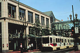
The most visible symbol of the Downtown Plan was the bus mall which was built on two north-south streets through the heart of downtown. The mall made bus service more understandable, improved the pedestrian environment and speeded bus travel times. Light rail was built on two east-west streets, intersecting the bus mall at Pioneer Courthouse Square in the center of the downtown retail district. Office and retail buildings have been renovated or built along the line, including Pioneer Place, an office and retail complex near the Square.
Downtown development projects have had limits on the number of new commuter parking spaces allowed since the mid-1970s. Office buildings on the mall can provide only 0.7 parking spaces for every 1,000 square of office space, while buildings farther away are allowed more, but never more than two spaces per 1,000 square feet. These limits have shrunk the supply of downtown parking from 3.4 parking spaces for every 1,000 square feet of office space in 1973 to 1.5 spaces in 1990.
Neighborhoods
Most of the neighborhoods served by light rail were already developed when light rail was built. No changes were envisioned, or have occurred, in most single-family residential areas. But some suburban areas were ready for redevelopment and infill.
Nothing happened during the recession of the 1980s, but more recently a number of apartment buildings have been built adjacent to the line. For example, a 90-unit apartment complex was recently completed adjacent to the Gresham Central station. This project uses 0.58 acre of land acquired by Tri-Met for the light rail project plus 2 adjacent acres. The project includes a pedestrian promenade connecting the apartments to the station. This innovative project was partially financed with federal Congestion Management Air Quality (CMAQ) funds, which the region has designated for transit-oriented developed.
The only large vacant tract of land along the eastside light rail is a 130-acre parcel west of Gresham City Hall. After initial plans for a regional mall fell through, the land owner, the city, Tri-Met and Metro (the regional transportation and land use planning agency) jointly developed a plan for a mixed-use, transit-supportive neighborhood, called the Gresham Civic Neighborhood. Development is now underway.
Public policy has supported and encouraged development near the light rail system. When the eastside line was planned, Tri-Met, the cities, county and Metro jointly conducted market studies and developed plans for all the stations.
Some stations were moved during this process to better capture development potential or to eliminate pressure to develop in single-family neighborhoods. The result was station area zoning that allowed higher density development near many of the stations and regulated building set-backs, parking lot locations and sidewalks.
This planning made it possible for transit-oriented development to occur, but did not guarantee that it would.
Part of the strategy of encouraging light rail use is to locate public buildings and subsidized development along the route. The Oregon Department of Transportation, the State of Oregon, Metro, Bonneville Power, the Port of Portland and other governmental agencies have built or renovated offices along the route. The state and region invested $85 million in the Oregon Convention Center and $34 million (about 15 percent of the cost) in the Rose Garden Arena. The city's economic development agency was a major player in Pioneer Place and some of the other projects along the routes.
The business community has also supported upgrading the pedestrian environment in the two major business districts -- downtown and Lloyd Center. Property owners in each location formed a local improvement district to provide the local match for funds to upgrade sidewalks and street pavements and to provide benches and artwork.
Merchants have supported these projects because they have received much more in improvements than they spent. Pedestrians benefit from a pleasant environment in which to walk, shop and wait for transit.
Lessons learned for future development The lessons learned about transit-oriented development on the eastside are now being applied to the westside project. This line has more opportunities to develop transit-supportive communities because there are four tracts of 100 to 400 acres of vacant land along the route. A corridor-wide planning effort of the cities, counties and transportation agencies is developing transit-supportive zoning, capital improvement plans and implementation strategies for each station area.
A public-private master planning effort is being used to develop master plans for some of the large vacant parcels. These plans include site designs and market analysis for actual projects. While planning has been taking place, interim zoning was adopted to prohibit certain auto-oriented uses, require minimum densities, limit parking supplies and orient any development that occurs to the stations.
The legislature has also authorized the use of tax abatements to encourage multi-family housing and mixed-used development within walking distance of transit, and Tri-Met has developed model ordinances. Previously, Portland was the only city that could use tax abatements for housing, and that use was restricted to downtown.
This planning is already producing results.
The Steele Meadows subdivision offers detached single-family homes on 1,700 to 2,500-square-foot lots within walking distance of a station. A 562-unit complex of townhouses and apartments is nearing completion at Beaver Creek, one of the large vacant tracks. Ground has been broken on the Beaverton Round, a mixed-use project in downtown Beaverton. Condominiums are being built on a triangle of land between the tracks in a mixed residential and commercial area immediately west of downtown Portland.
Essentially the region is building the transit system that regional leaders adopted in the 1970s. While the automobile remains the dominant mode of travel, light rail has been embraced as a way to improve transit service and to focus growth.
Partnerships between government and private land owners, businesses, and developers have helped create compact residential and employment areas near light rail. Public support has made it possible to innovate with new designs, smaller lots and more mixed-use projects.
It all add up to a more livable region with interesting places to live and work and choices about the ways to get around within the region.
Judy Davis is a senior planner in the Portland office of Parsons Brinckerhoff Quade & Douglas, a transportation engineering and planning firm headquartered in New York City.
 Return to design '97 top page Return to design '97 top pageCopyright © 1997 Seattle Daily Journal of Commerce. |