![[Protecting the Environment]](envirocover.gif)
PROGRAM MAKES A PC A POWERFUL TOOL
BY JOE CLOUD As head of the Facilities Planning Division for the U.S. Navy's Submarine Base Bangor, George Shepard has a variety of land and facility planning assignments for this 7,000-acre base on the Hood Canal, home of the Navy's Pacific Trident submarine fleet. Up until last month, when a request for a facility siting study or information regarding potential environmental impacts would cross his desk, Shepard would respond the way facilities planners and managers have for the past 25 years -- review the information request, go to a wall map and identify the area in question, go to the flat files and pull out the relevant maps and floor plans, go to the bookshelf and pull down his most current master plan (frequently prepared years prior), identify potential constraints and other relevant planning data, perhaps go back to the bookshelf and review bound copies of recent facilities database output. He would then spend most of the day photocopying maps, preparing other graphic exhibits, and writing a summary memo to accompany his exhibits. These would then be routed to the appropriate
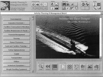
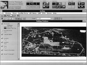
But today things are different. Shepard sits at his Pentium-based desktop computer and launches a Windows-based planning tool which integrates databases, text, photos and spatial data. His system includes a base-wide mapping system, various facility databases, and other reference material such as environmental status reports with his basic word-processing, spreadsheet, presentation and database applications. Working with a customized Graphical User Interface which integrates all of his various applications, he can analyze the request and prepare a response memo, toggling back and forth between site maps, facility maps, database information and word processing. He can copy and insert any supporting material such as constraint map images or spreadsheet data into his memo, simultaneously saving the images to be inserted into his presentation software application should he later need to brief decisionmakers on his analysis. A comprehensive memo replying to the information request can be generated in an hour or so, complete with supporting graphics and data. This memo can be printed and routed conventionally, distributed through his basewide Local Area Network (LAN), or sent as an e-mail attachment through the Internet to a Washington-level command. Perhaps best of all, while he is doing this, the system is being simultaneously used by other planners, engineers or authorized users for their own purposes.
The Bangor system is one of many APMMs developed for the Navy by the San Francisco-based planning and landscape architecture firm of EDAW, Inc. Although known as a design firm (current local projects include the redesign of the East Capitol Campus grounds in Olympia, and the design guidelines for redevelopment of Sand Point), the Seattle office of EDAW is a multi-disciplined office providing consulting services in landscape architecture, planning, and biology. EDAW Seattle led a multi-office team for the eight months it took to develop the APMM. EDAW started by interviewing subase personnel to develop an understanding of their business needs, then moved forward on separate tracks creating the user interface, updating the mapping systems and modernizing existing databases, finally delivering the completed product on a CD-ROM. Among the various software applications integrated into the APMM and available at the click of a button is AutoCAD drafting software, Arcview GIS interface, and the complete Microsoft Office Pro suite. The system is designed as a repository for hundreds of facility-related digital images, presentation slides and published documents in a compressed, indexed and hyper-linked format. Finally, although the product was created and delivered by EDAW, Shepard's office can add files, images, screens and actually redesign the user interface to a degree, thanks to a `system manager' application which EDAW designed and built into the system. The APMM is one of a family of automated planning products being developed by EDAW to provide customers with tools to work with environmental, community, and master planning situations. A similar system for the newly incorporated city of Woodinville is in the prototype stage, based on the city's new Comprehensive Plan, prepared by EDAW. As part of that planning process, EDAW helped Woodinville create a GIS system, developed parcel data overlays for the system and linked land use inventory data and assessor's data to those individual ownership parcels. With the automated data in place, EDAW realized that it could be leveraged to build a much more useful system by linking it with other tools. The Woodinville prototype works as an automated comprehensive plan which could be used both as a public information system and an operations tools for city staff. The prototype currently includes permit tracking software (in this case, Tidemark), and is designed to be expanded to cover public works, planning and financial applications. The Woodinville prototype also provides for links to regional planning data, enabling planners and public works engineers to integrate with surrounding cities and to coordinate in multi-jurisdictional issues. "As a small, new city, we are always looking for ways to do more work with less staff and to involve our citizens and city officials. The automated planning products EDAW has created are ideal for both," according to City Planning Director Ray Sturtz. Other automated planning applications currently under development by EDAW include a system for management of a new campus of James Madison University in Virginia, and a system for the Contra Costa Water District in Northern California for use in balancing water supply and demand. A regional information management system for the Navy is also in the planning stages. It is intended to provide the Navy with regional facility planning capability. Based on a combination Internet/intranet model, it is intended to alow the Navy to better communicate and share information -- initially among the various Navy bases around the Sound, and potentially with other Department of Defense activities, such as Fort Lewis and McChord AFB, cities and counties, and regional planning agencies. EDAW is an international network of small offices and has had a firmwide Wide Area Network (WAN) in place for several years, which allows employees to share computer-aided design and drafting (CADD) and geographic information system (GIS)-based design and planning work, as well as perform typical communication functions. The firm's experience with LANs and WAN showed the productivity increase that can come from working within a fully-networked environment. EDAW recently created a separate division within the firm to support automated planning efforts. Known as the Integrated Solutions Group (ISG), based in Alexandria, Va., it has Windows and Internet programmers, database developers, GIS and AutoCADD experts, and other related computer professionals. A growing area of interest is helping clients take a more integrated look at design and planning. EDAW delivers dozens of construction document sets and GIS-based planning products to clients annually. Most of those products are digitally based. Rather than see them as an end product of a construction or planning contract, EDAW encourages their clients to see these as potential living tools with real value built in. These drawings and documents can become the basic building blocks of systems similar to the APMM. With the current emphasis within the software industry on making programs interactive and compatible, there is now the opportunity to take CADD products, link them to powerful desktop-based databases, and create planning tools which function well for users with minimal computer skills. Perhaps the most compelling quality of these new systems is the ability to bundle a broad spectrum of unlike data which are linked mainly by their common relationship to a particular land or facility asset. These data sets can include floor plans, thematic maps, hazardous material data, digital imagery or photographs, reference documents, published instructions or operations manuals, personnel data, company phone books and commonly used software applications. Once designed and built, such systems can be reorganized to respond to future circumstances if need be. As modular systems, built around commercial off-the-shelf software, they can evolve to take advantage of changes in the software industry. While portions of these systems may eventually be outgrown, the data remains intact and can evolve into a new format, thus guarding the value of the initial investment. Today, the Bangor APMM is used principally by Shepard's planning group. Future expansion of the system may include utility planning and design capability, disaster preparedness planning, waterfront operations, facility management contracts administration and environmental reporting. The information age arrived in the 1980s with the advent of the desktop computer and increasingly available data. With the spread of networks and the Internet, the 1990s is the age of information management.
Joe Cloud is an associate in the Seattle office of EDAW, a landscape architecture and planning firm. |
 Return to Protecting the Environment top page
Copyright © 1996 Seattle Daily Journal of Commerce.