![[Protecting the Environment]](envirocover.gif)
CHANGES IN FORESTRY
BY DAVID COX Back in the 1930s, a forester's tool bag consisted of a compass, an Abney level, a tape measure, and, hopefully, a map. He would head out in the morning, often hiking many miles, in search of the stand of trees to cruise that day. Going would be rough as the forester scrambled over huge downed logs and through thickets in the virgin old-growth forests of the day. Upon reaching the stand, he recorded tree measurements with paper and pencil, data to later be used in the office with a slide rule to estimate volume. The forester's tool bag of the 1990s is completely different. Leaving his or her laptop in the truck, the forester locates his position by bouncing radio waves off two distance satellites using a Geographical Positioning System (GPS) receiver. Cellular phones allow the forester to be in nearly constant contact with the office. Ownership and boundary lines are established using a laser rangefinder rather than string lines. The tree measurements taken are greatly improved using a relascope and the data is recorded on a handheld computer, which
Back at the office, Geographical Information System (GIS) tools use satellite imagery and aerial photos to create accurate maps that display the stands by vegetation types and other useful variables. Technology impacts our lives slowly in ways only recognizable when one looks back at the changes over a longer period. It impacts not only how we communicate and travel, but also how we work and live. Although not as immediately apparent to many, technology also has had a profound impact on the science of forestry and how land can be managed more efficiently and productively. Carl Newport, a former shareholder of Mason, Bruce & Girard, Inc., has been helping private and public landowners manage forest properties since 1957. Dr. Newport summarized changes in forestry over that period by observing that as in other industries, technological change appears to be accelerating. "In 1952, when I led my first forest inventory crew, there were no roads, only trails, in remote mountain timber areas," Newport said. "The crew went in on foot and horse. It took two days to set up the cook tent for my wife and tents for the crew. I typed the timber by lantern at night. The plot samples were compiled on crank-type calculators during the two months we were there. Now, I would get a helicopter, take my laptop and type maps made from aerial photos with computers." Most forestry experts expect this acceleration of technology to continue. While recent publicity has chronicled the demise of forestry in the Northwest, most of the impact is related to timber practices on public lands. But in Washington, alone, forest industry lands still comprise about 3.8 million acres and other smaller private lands comprise another 2 million acres. Forestry remains an important part of the economy here and in many other areas of the United States. But the methods and procedures forestry firms use today are very different. Helping landowners develop inventories of their timber is a good example. Landowners base future actions on important variables that inventories supply: forest value, forest health, forest growth, indications for change over time, potential harvest levels and projections of short-term and long-term cash flow. In the past, forest inventories were designed to provide estimates of total forest volume. These designs called for locating a series of samples in the forest and conducting statistical tests to determine predicted volumes for the entire block. Ideally, however, forests should be sampled by individual stands which vary in productivity, age, stocking and
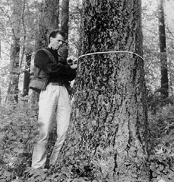
In the old system, forest growth and catastrophic losses such as wind or fire damage and timber harvesting made inventories difficult to keep current. Changes to the inventory were next to impossible because many of the plot locations were not geographically referenced, and the sample design could not be amended. Since maintaining up-to-date inventories was expensive and time-consuming, many property managers made do with incomplete or outdated information until a complete new inventory eventually was conducted. Today, advanced computers and mathematical modeling systems have greatly increased the ability of mangers to conduct and maintain inventories. In most cases, costs associated with this activity also are lower relative to total management costs. Some of the larger forestry consulting firms are continually developing new software to solve clients' current problems and address new needs as they arise. New technologies have impacted not only the way inventories are designed, but also the way information is collected. In modern forest inventory, a geographic information system (GIS) forms a foundation for this process. GIS allows computer operators and technicians to produce maps that are geographically referenced; unique forest attributes are noted and mapped relative to their actual location on earth. These GIS systems, such as ARC/INFO or PAMAP, are based on complex computer algorithms, enabling foresters to store massive amounts of information for extremely large properties which regularly range up to 500,000-acre tracts. Unlike traditional random sampling, GIS makes it possible to collect inventory data by stands. The similarity of characteristics between stands allows statistical expansion to uncruised areas, thus reducing the amount of field work necessary. Timber estimates of stands are then compiled to determine total volume estimates, which can be added in a variety of ways to represent various ownership groups or tracts of land. Despite computers and other technological advances, the actual number and types of forest measurements have not changed much over the last 40 years. Modern foresters still look at the same physical characteristics as their predecessors: tree height, tree diameter, taper points at different places on the tree stem, the amount of crown, and defect or rot. But today many new tools are used to aid foresters in gathering, storing and processing data:
Collecting detailed information about individual trees and stands lets foresters project growth not only in uncruised areas, but into the future. Tree heights, diameters, spacing and health are the variables that drive forest growth models. These models, combined with GIS systems which track the areas harvested each year, allow landowners to maintain current inventories. Periodic sampling of stands on a five to 10-year basis keeps such inventories continually up-to-date. Inventory procedures go beyond collecting just tree data. Landscape management requires the collection of information pertaining to both plant and animal communities as well as animal habitat. Using handheld data recorders, foresters can record a multitude of statistics, such as the amount of woody debris or the variety of plant species in the forest understory, which are analyzed as indicators of forest health. The software in these handheld computers have built in error trapping procedures which minimizes typographical mistakes and other errors. The data is downloaded directly to computers when processing is complete. As newer technologies become available in the decades to come, foresters surely will gain an even more accurate knowledge of the land they manage. But their objective will remain the same as it has for many decades, advising property owners on how to best achieve the goals they have decided upon for their land while maximizing the benefits desired by forest owners.
David Cox has been a principal in MB&G since 1978 and has 25 years experience in forest economics and policy analysis. MB&G is a Portland-based forestry consulting firm that has been in business since 1921. |

 Return to Protecting the Environment top page
Copyright © 1996 Seattle Daily Journal of Commerce.