![[Protecting the Environment]](envirocover.gif)
HYLEBOS WATERWAY HAS GOTTEN MUCH CLEANER
BY BETSY STRIPLIN and PAUL FUGLEVAND A remediation study of Hylebos Waterway sediments is turning up evidence that these sediments have recovered significantly over the past several decades. Hylebos Waterway is one of the industrial waterways in the Tacoma tideflats. It contains two of the nine high priority problem areas originally identified in the US Environmental Protection Agency's (EPA's) Record of Decision for the Commencement Bay Nearshore/Tideflats Superfund site. Industries bordering or draining into the waterway include boat yards, chemical manufacturers, a smelter, a refinery, log yards, sawmills, marinas and a scrap metals recycling facility as well as other smaller facilities. Following EPA findings in the 1980s, the Washington Department of Ecology was assigned responsibility to control discharges into Commencement Bay. In late 1993, the EPA initiated a "pre-remedial design" program for Hylebos Waterway. The program's objectives are to reevaluate the 1980s findings and to determine the areas of the waterway that currently require cleanup, to estimate the associated sediment volume, and
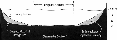
To locate the areas that may require sediment remediation, the committee has conducted extensive sampling and analysis in Hylebos Waterway over the past two years. Results to date show that the waterway is considerably cleaner than it was in the mid-1980s and that the volume of sediment that may require remediation is far less than originally estimated. Surprisingly, the data also show that certain impacts to sediment dwelling organisms are not due to hazardous chemicals as was previously assumed. Instead, typical waterway activities, including prop wash from ship traffic, organic debris from the movement and storage of log rafts en route to the saw mills and log ships, and shoreline protection structures (riprap) adversely effect marine organisms that typically live in subtidal sediments. One of the challenges facing the HCC is to perform the pre-remedial design program in a technically sound manner that remains cost-effective. A conceptual model was developed to remap the "subtidal surface" and aid in selecting where to sample sediments. The subtidal surface is the top few inches of the bed of the waterway which is located deeper than the mean lower low water (MLLW) level. Using the model, locations and amounts of sediments that have accumulated in the waterway since it was last dredged were determined by comparing recent waterway topography to the oldest recorded topography for the entire waterway. The resulting map (see attached hypothetical figure) shows where sediment has actually accumulated in the waterway during the time of industrial discharges. This map allowed the HCC to focus sediment sampling on areas where contaminated sediment is most likely to be found and cut the required sampling to about half. To date, the HCC has gathered sediment quality data at 85 subtidal stations. (The HCC generated data for 57 stations and received data from the Natural Resource Trustees for the other 28 locations.) Fifty stations (59 percent of the total) show chemical concentrations that exceed ecological sediment quality objectives (SQO), the chemical criteria used to identify sediments requiring cleanup based on protection of the biological community. Under the Record of Decision, biological testing can be used to overrule the sediment chemistry results for chemicals that can cause ecological impacts. Of the 50 stations that exceed allowable contentrations, biological results are available for 28 stations. Only 17 stations exceed biological criteria, and these stations are concentrated at the mouth of the waterway or scattered at isolated locations within the middle and upper portions of the waterway. The biological results reduce the size of cleanup by as much as 25 percent to 50 percent compared to the volume predicted by chemical criteria, and show that chemical testing alone is not a 100 percent effective predictor of contaminated sediment. The use of direct biological testing along with consideration of areas affected by prop wash and organic debris is the best approach for identifying contaminated Hylebos sediments that would actually benefit from remediation. In addition to defining the extent of chemicals in the waterway, the cleanup committee's studies also show large amounts of organic material in the upper half of the waterway. This organic material appears to be wood debris from historic sources and/or current transport and storage of logs for the saw mills and log yards located along the upper half of the waterway. This commercial activity has resulted in organic loading to the sediment which has caused alterations to the marine habitat. It also appears to have caused the sediment to become toxic to some marine organisms.
To support the evaluation, a sediment profile survey was completed which provided undisturbed photographs of the top eight inches of sediment in the waterway. This inexpensive method for rapidly assessing sediment habitat provided data to identify areas of the waterway which were strongly affected by organic loading, as well as areas disturbed by prop wash from ships. At the 57 HCC testing locations, chemical and select biological analyses were also conducted on subsurface sediments. The subsurface sediments under study extend from the surface of the sediment to at most 12 feet below the surface. These sediments were sampled by taking cores which were sectioned by four-foot intervals. The sediment within each four-foot section was mixed prior to being sent to the laboratory for analysis. Notably, chemical concentrations were almost always greater in the upper core sample (extending from the sediment surface to four feet down into the sediment) than in the surface samples. This clearly indicates that the surface sediments are now cleaner. This natural recovery of the sediments has resulted from source control actions such as the reduction or elimination of wastes discharged by storm drains and industries into the waterway, coupled with the addition of cleaner material from inland sources (via storm drains), the Hylebos Creek, and the Puyallup River. With over seven miles of shoreline, a sampling approach that would adequately characterize the intertidal banks without being prohibitively expensive was required. The intertidal banks run from the mean lower low water level to 12 feet above that level. The HCC developed an integrated sampling approach that included sampling point locations suspected to be source materials, and larger areas where multiple samples were composited or mixed together to represent average conditions along the bank. The potential source material areas and the individual composite areas were identified based on a visual inspection of all seven miles of shoreline. This inspection was a cooperative undertaking which included the EPA, HCC personnel and technical consultants. Survey participants defined the composite areas by the use of existing property lines and by encompassing areas of similar bank conditions such as sediment type and slope. The composite areas stretched from 50 feet to nearly 1,000 feet along the bank; the average composite area ranged from 150 to 300 feet long. At this time, only chemical data are available for the banks of Hylebos Waterway. The data show that the banks contain generally higher concentrations of chemicals than sediments from the subtidal portions of the waterway. The Hylebos Cleanup Committee has stepped forward to accomplish this comprehensive process in support of EPA's cleanup goals, and ultimately to identify and, if necessary, remediate select waterway areas. To date, industry source controls on discharges to the waterway have resulted in the substantial reduction of chemicals reaching the waterway. These controls will enhance the quality of waterway habitat for invertebrates and fish. The HCC is evaluating a number of potential disposal sites for contaminated sediment that may be dredged as part of the waterway cleanup. This process, coupled with the ongoing sediment natural recovery and chemical mobility studies, will help to determine the final remediation strategy. Completion of the pre-remedial design program is anticipated in early 1998. At that time, recommendations on remediation areas and disposal alternatives will be available for public comment. The program will then enter a remedial design phase to determine effective engineering solutions for remediation.
Betsy Striplin is president of Striplin Environmental Associates, Inc., an Olympia-based consulting company. Paul Fuglevand is senior consulting engineer for Dalton, Olmsted and Fuglevand, Inc., a Bothell-based consulting company. |

 Return to Protecting the Environment top page
Copyright © 1996 Seattle Daily Journal of Commerce.