|
| |
|
|
Working through ESA Salmon Listings
By MICHAEL A. WERT and RICHARD W. MYERS
On March 9, the National Marine Fisheries Service proposed the listing of Puget Sound chinook salmon as a threatened species under the Endangered Species Act. This decision, in combination with a variety of water resource management issues facing the Puget Sound region and the entire Northwest, will have far-reaching effects.
If the chinook is listed, this will mark the first time in the nation's history that a major urban area's land and water resource management decisions would be regulated under the ESA. Compounding this are proposed (and pending proposed) ESA listings for bull trout, sea-run cutthroat and coho salmon. Clearly, the future will not be "business as usual."
Programs are being planned or implemented by various interests in hopes of avoiding the impacts of the listing, but several representatives from The National Marine Fisheries Service (NMFS), which has jurisdiction over the status of species, indicate that despite these efforts, it's a matter of when -- not if -- the chinook listing will occur.
Once fish listings occur, federal ESA authority will directly affect local governments, tribes, port districts, fishing interests and development in the region. Anticipation of these listings has already caused a cascade of activities as public and private sectors attempt to plan for the future.
The extent of the impacts is not known, but it is clear is that a salmon recovery program will place restrictions on a broad range of land use and recreational activities that affect the region's natural resources. Attendant costs will be shared by all.
It's time to step up to the challenge to resolve this important natural resource management issue or suffer the consequences of federal mandates that could result in a train wreck involving government resource managers, public and private water users, commercial and recreational fishing interests and the tribes.
Seeking solutions
The salmon life cycle is complex. It involves the ocean, estuaries, rivers, streams, wetlands and lakes, so the region's salmon recovery program will need to involve a wide range of participants. Resource agencies have initiated planning discussions and have generally agreed on how salmon runs have been adversely affected.
Known as the "Four Hs," the primary causes for depressed salmon runs include:
Other factors also have affected salmon stocks.
Resource agencies are now focusing on how to mitigate the impacts that result from these causes. A regional salmon recovery program will need to consider a myriad of potential solutions, ranging from regulatory reform and cross-program coordination, to treaty rights and the federal statutory trust responsibility, and overall water resources management.
Many elements of a salmon recovery program will be the primary responsibility of agencies, but the management of water resources will be the combined responsibility of agencies, developers and property owners.
Mitigation: current and future tool
Increased development, urbanization and the impervious surfaces they bring have resulted in elevated levels of pollutants in runoff entering local water bodies. This degradation in water quality is at the heart of the salmon protection issue.
Revised standards can be expected after state and local regulations have been reviewed for effectiveness in protecting salmon. These changes could include the development of new best management practices for construction and operation of projects. In addition, requirements for increased buffer zones along wetlands and other waters could occur, reducing the area of buildable land on some parcels.
Increasing buffers around wetlands, creeks and rivers would be implemented through local ordinances that would provide specifications for wetland and stream mitigation plans. Plans developed under such specifications in the future likely will be more arduous than those currently being created. In addition, longer and more involved monitoring can be expected to ensure plans are achieving the desired results of salmon recovery.
Wetland and stream restoration/mitigation plans are already recognized as valuable tools in improving salmon habitat. While not yet mandated under ESA, developers from both the public and private sectors have implemented project mitigation designed to protect salmon resources.
Three projects that show evidence of positive results are improvements to King County's Avondale Road, the First Avenue South Bridge and the Emerald Downs Racetrack.
Avondale Road/Bear Creek
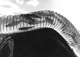
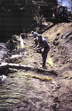
As part of a widening project on Avondale Road in King County, Shapiro and Associates designed and provided construction oversight for a stream restoration plan on a 1.5-mile reach of Bear Creek. This stream supports cutthroat, chinook, sockeye and coho salmon. The effects of increasing urbanization in the watershed necessitated a plan of action to protect these fisheries resources.
One challenge of the project was to find the most effective methods to restore segments of the stream while stabilizing the channel and improving the natural habitat. A variety of bank stabilization methods and in-stream structures were used to achieve these objectives.
First, stream banks were cleared and excavated. Then rocks, logs and root wads were installed at the water line to slow the velocity along the bank. Slower water velocity reduces channel and bank erosion and siltation, enhancing the quality of salmon spawning areas.
After the water line was stabilized, the remaining bank was restored. Previously excavated soil was wrapped in erosion-control fabric and then layered with willow cuttings up the sides of the stream bank. As the willows have become established, they have provided shade that cools stream temperatures. Insects falling from the willows also provide a food source for salmon.
Another feature of the project was the construction of a culvert on Cottage Lake Creek, a tributary to Bear Creek. The culvert was built to provide fish passage, and habitat features around the culvert were designed to further enhance salmon habitat.
First Avenue South Bridge/Duwamish River
When plans were formulated for modification of the First Avenue South Bridge and redesign of nearby intersections, the City of Seattle and the state Department of Transportation included the restoration of a 2.6-acre tidally-influenced wetland within the bridge corridor. This restoration helped to offset impacts from the proposed project.
A major challenge facing our firm in the design of the wetland mitigation plan was taking a degraded industrial area and restoring it to a condition that would benefit wildlife, including salmon. In the restoration process, a channel was constructed to connect the wetland to the Duwamish River. Then a wetland and upland buffer were created by planting native trees, shrubs and estuarine wetland plants to provide habitat beneficial to Duwamish River fall chinook, coho and chum salmon.
The project created resting areas and a food source for fish. However, because it is a tidally-influenced wetland that contains mudflats, salmon are only able to use the improved habitat during high tide periods.
Based on site monitoring, the plantings are becoming established and the desired fish and wetland habitat has been successfully created.
Emerald Downs/Mill Creek
As part of the Emerald Downs thoroughbred racetrack project, a stream on the property was restored to a more natural configuration. Mill Creek, which feeds into the Green River, was converted from a linear agricultural ditch to a meandering channel.
Our firm designed the mitigation plan for this effort, which resulted in a more natural stream with native trees and shrubs to provide cover and a food source, and a stream bank enhanced by the addition of woody debris that created cover and resting places for salmon.
Michael Wert is a water resources manager and Richard W. Myers, ASLA, is a landscape architect in the Seattle office of Shapiro and Associates.

Copyright © 1998 Seattle Daily Journal of Commerce. |