
Surveys
DJC.COM
April 9, 2009
Olmsted followers celebrate A-Y-P Centennial
Brooks Kolb LLC Landscape Architecture

Kolb
|
Many, if not most, Seattle residents experience the University of Washington campus only in quick glimpses of Frosh Pond’s dramatic Drumheller Fountain rising above a green ramp of turf as we drive by on Montlake Boulevard Northeast or in our impressions of the park-like borders along 15th Avenue Northeast and Northeast 45th Street.
Even more fleeting is the view of the city on a hill that I always look for when I steal a glance at the campus while rushing by on the Interstate 5 bridge. We sense that the campus is a landscape and a cityscape that has been deliberately planned, but even some of the area’s longtime residents may not be fully aware that the campus we know today is the direct expression of the Alaska-Yukon-Pacific Exposition of 1909.
Enlightened planning by city and state officials more than a century ago ensured that a landscape planned for a temporary world’s fair would endure as a centerpiece of Seattle’s civic, cultural and intellectual life.
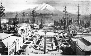
Historic postcard images courtesy of Friends of Seattle’s Olmsted Parks Geyser Basin (now UW’s Drumheller Fountain) and Rainier Vista, served as a centerpiece to the Olmsted Brothers’ Alaska-Yukon-Pacific Exposition plan. |
Even more intriguing is the fact that the core of today’s campus and the exposition itself were designed by the same renowned landscape architects who laid out Seattle’s entire park and boulevard system; namely the Olmsted Brothers of Brookline, Mass., and lead designer John Charles Olmsted in particular. The Olmsted Brothers were hired first to design a university campus enlarged from the earlier Oval Plan, then to design the exposition grounds and lastly to redesign the campus based on the exposition plan.
The centerpiece of the Olmsteds’ A-Y-P plan was Geyser Basin (now Drumheller Fountain), so named because it featured a tall water jet resembling the natural geysers at Yellowstone National Park. Radiating out from Geyser Basin like the spokes of a giant wheel were three axial landscaped avenues, each focused on a particular view: Lake Washington and the Cascade Mountains, Union Bay, and in the center, Mount Rainier.
The central avenue (today’s Rainier Vista) began at a higher elevation north of Geyser Basin, allowing construction of Cascade Court, with its centerpiece of six waterfalls with a flow of 14,000 gallons per minute, which descended the hill toward the basin. As John Charles Olmsted described it in November of 1906: “The magnificent views of Mt. Rainier and other mountains and of Lake Union will … be by far the greatest features of the exposition and will be vividly remembered by most visitors when the best efforts of architects and landscape gardeners have been forgotten.”
The other two avenues were oriented at 40 degrees east and west of Rainier Vista and proceeded down-slope from the basin. The Lake Washington and Lake Union vistas featured views of the lakes framed by Douglas firs. All three vistas were laid out to allow substantial space between buildings in order to incorporate as much of the remaining native forest and undergrowth as possible. They were connected by two concentric circular avenues: the upper circle, called Pacific Avenue, is today’s Stevens Way; the lower connecting route was the railroad line, which is today’s Burke Gilman Trail.
Linking up
One of the significant aspects of the Olmsted plan for the exposition was its proposed linkages to the overall Olmsted system of city parks and boulevards. In particular, the plan called for the boulevard to connect, after the exposition, through the campus north to what is now Ravenna Boulevard. On the south, the exposition connected to Washington Park (now Washington Park Arboretum) and Lake Washington Boulevard by crossing Montlake Portage, the strip of land which since 1917 has been bisected by the Montlake Cut portion of the Lake Washington Ship Canal. Visitors could also arrive at the exposition grounds by boat, with docks provided both on the Lake Union and Lake Washington waterfronts.
While only a few of the original A-Y-P buildings have survived, this basic campus layout has been preserved and continues as a framework for future campus planning. The most notable changes are that Red Square has replaced the U.S. Government Building and plaza at the top of Cascade Court and that the two curving exposition buildings flanking Geyser Basin have been replaced by the Chemistry Building west of Frosh Pond and a quadrangle east of the pond.
According to Karen Kennedy, a UW master’s student in landscape architecture: “The legacy of the A-Y-P on the University of Washington campus is evidenced by both the spatial relationships and artifacts still in existence. In many ways, Olmsted laid the framework for the campus’s future development through his design. The most famous element is Rainier Vista, but more remains than just the view, open space and location of the fountain. The vista’s landform, with its gradual downward slope toward the south-southeast as well as its width as established by the two remaining parallel paths on either side exists relatively unchanged.
“The A-Y-P routes of Alaska Avenue and the southern part of Pacific Avenue, now collectively known as Stevens Way, today provide the primary automobile access through campus. The A-Y-P’s main entrance at 40th Street and 15th Avenue is still heavily used, and the two pedestrian underpasses for the railroad at Rainier Vista are intact. In addition, several artifacts, including three buildings, pieces of stone walls, stands of mature trees and circulation routes can still be seen on campus.”
Walking tours
In celebration of the centennial of this remarkable design and planning achievement, the Friends of Seattle’s Olmsted Parks (FSOP) has scheduled a series of monthly A-Y-P campus walking tours on Saturday mornings that will begin on April 25 and continue through Sept. 26, reflecting the period one hundred years ago when the exposition was open to visitors. The first tour will meet at 10 a.m. at Cunningham Hall. All subsequent tours will meet at 10 a.m. at the Burke Museum, owing to the fact that Cunningham Hall, which is one of the few remnant exposition buildings, is actually going to be picked up and moved elsewhere on campus. The walking tour dates are May 30, June 27, July 25, Aug. 29 and Sept. 26.
Additionally, FSOP is producing a brochure called “Guide to the Olmsted Legacy on the University Campus,” which will be available at the walking tours and other venues. We will present a lecture on the A-Y-P legacy at the Museum of History and Industry on June 20 at a symposium jointly planned by Historic Seattle, the museum and FSOP.
The FSOP brochure and walks are supported in part by a grant from Humanities Washington.
Many other organizations will also be celebrating the A-Y-P Centennial in various ways this spring and summer, each concentrating on a different aspect of the exposition’s legacy, since it is significant to the social, architectural and landscape history of Washington state. Historic Seattle, HistoryLink.org, the UW, and the Museum of History and Industry are a few of the participating organizations. For more information about A-Y-P Centennial celebrations can be found at http://www.aype.org and http://ayp100.org.
Brooks Kolb, ASLA, is president of Friends of Seattle’s Olmsted Parks and principal of Brooks Kolb LLC Landscape Architecture. This article contains excerpts from the “Olmsted Centennial News — 2009 A-Y-P Edition,” published by FSOP and edited by Jerry Arbes and Anne Knight with contributions from Jennifer Ott and Karen Kennedy.
Other Stories:
Copyright ©2009 Seattle Daily Journal and DJC.COM.
Comments? Questions? Contact us.