DJC.COM
August 9, 2001
Public places — look between the buildings
CityDesign
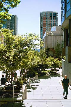
Photo by Jason Cooper/CityDesign University Street at Benaroya Hall is both a functional street and a gathering place. |
Center City Seattle — the region’s core, and the basin defined by Lake Union, Elliott Bay and the slopes of Queen Anne, Capitol Hill, First Hill and Beacon Hill — is changing dramatically. Recent visitors have commented that the city looks as though it was were built entirely within the past 10 years.
Fueled by both the public and private sectors, the construction boom is bringing dozens of new buildings and defining new places. Areas like Belltown, previously characterized by modest housing, light industry and the arts, is fast becoming a high-density, upscale neighborhood. Denny Triangle, in recent years serving as downtown’s fringe parking lot, will soon become the next mixed-use neighborhood of even higher density. South downtown is an entirely new place, and the Civic Center will become the symbolic heart of government.

Rahaim |
Who is defining the character and quality of this growth? In April 2000, I wrote in the Journal of Commerce about “Connections and Places’, the city’s urban design strategy for Center City. Just underway at that time, the goal of the strategy is to define the physical character of the city’s public realm — the streets, parks, plazas and waterfronts that we all share. The strategy recognizes that Seattle will grow and change while retaining its special qualities only if we pay special attention to the public places — namely, those areas between the buildings being built.
With remarkable support from all players including Mayor Schell, the Seattle Design Commission, City Council, the Center City neighborhoods, and the development community, CityDesign has proceeded with Connections and Places and its first component, the Open Space Strategy for Center City.
The Open Space Strategy will become a framework for an open space system, defined by streets, public parks and private plazas. It will be a long-term, 100-year vision for this system, and a short-term, 10-year strategy for implementing phase one of that system. The short-term component will define a discrete number of projects, certain streets and open spaces, to be undertaken over the next decade, that will be essential to making the system work over time. It will also include:
- Recommendations for improvements to key streets that connect existing and planned open spaces and important places.
- Guidelines for open spaces, private and public, that are of high quality and attractive for public use.
- Implementation strategies to realize new and improved streets and open spaces through a variety of regulatory and financial mechanisms.
With our lead consultant Mithun Architects, we have completed full documentation of the existing and planned projects and are beginning to look at ways to make sure these investments are connected and mutually reinforcing. For example, neighborhood plans identified a number of streets to be improved, but the chosen streets often change when crossing neighborhood boundaries.
Another example is South Lake Union Park, where adjacent street improvements and new private development could reinforce the access and visibility of this important regional facility. The Open Space Strategy will help define these connections and improvements.
What are some examples of recommendations in the Open Space Strategy?
Streets as open space
Streets are for more than just movement, they are the city’s main public spaces. The time we spend on a city street, whether walking or driving, window-shopping or sipping coffee in a café, is the way in which we experience the city. This experience is shaped by both public decisions in the actual right-of-way, and private decisions in the buildings that line its edges — walking Pine Street is a pleasant experience not only because there is good paving, lights and trees, but also because there are active storefronts, cafes and color. The public and private actions work in harmony to create a wonderful street, one of the city’s better public spaces.
The strategy will suggest a variety of approaches to streets — a “typology” of five or six types to accommodate different needs. It will recommend that some streets, such as Westlake, could become great promenades with slow-moving traffic and broad sidewalks, while others like “greenstreets” could become the equivalent of neighborhood pocket parks, while still accommodating local traffic.
Other streets must remain major arterials for movement of cars and trucks, and their design and related land use decisions must reflect that purpose. Some may actually mix vehicles and pedestrians, like many European streets, or Market Place through Pike Place Market.
A central waterfront park
The decision to move the new aquarium to a site south of Pier 59 creates an unprecedented opportunity for a major waterfront park extending from Pier 59 to Pier 66. While some of this “park” space will be actually be on the water, its heart will be Pier 62/63, and it could extend east to capture a dramatic hillclimb to Pike Place Market.
The central waterfront park could effectively extend Pike Place Market — the city’s soul and its best public space — to Elliott Bay. While there are many uncertainties about the water’s edge due to the condition of the viaduct, connecting the market to the bay, and creating a major park on the water should be important goals regardless of the disposition of the viaduct.
Connection over and under I-5
The interstate is a substantial barrier between the eastern Center City neighborhoods and downtown. While physical connections exist at several streets — Pike, Pine, Madison, James, Cherry and Yesler — they are generally unpleasant for pedestrians to traverse. The strategy will recommend types of improvements at these locations to better strengthen the connections between these core neighborhoods and downtown, and to encourage foot travel.
12 projects approved
The Center City neighborhood plans have already defined many components of the Open Space Strategy, and implementation of these is already under way. Thanks to the investment of many private developers, 12 greenstreet projects have been approved and will be built by private developers with their projects. An equal number are in the planning stages.
By providing a focused staff effort to facilitate these projects, substantial improvements to the public street will be made at almost no cost to the public. The Open Space Strategy will develop similar implementation programs for the other recommended projects.
Over 120 people attended the first public event for the Open Space Strategy, an open house on June 20, to review the work-to-date and offer feedback. Many comments addressed specific needs and desires for parks, street improvements and access to the waterfront. The overwhelming sentiment, expressed in some way by all attendees (which included neighborhood residents, developers, city staff and business owners), was strong support for moving forward with this vision, to make sure that the result of Seattle’s current growth spurt is not just a collection of buildings, but real places.
Mayor Schell has said that Center City should be a place where one can walk from south downtown to Lake Union, and never get tired along the way because the path is always interesting, vital and fun. That path is made of city streets, public parks and private plazas that provide a stage for intense activities and make up an exciting urban experience.
We must take advantage of the opportunity now currently before us and create a vital open space network that will establish the character of Seattle’s core for decades to come.
John Rahaim is the executive director of the Seattle Design Commission and CityDesign, Seattle’s office of urban design.
Other Stories:
- The future is looking UP
- Urban form gets its roots from nature
- Downtown becomes a shopping mecca
- Earth-shaking discoveries impact design
- The scoop on infill development
- Infill problems? Get creative
- Rubbernecking leads urban retail revival
- Rx for Seattle’s growing pains: Collaboration
- DSA puts a downtown neighborhood on the ‘Edge’
- A blast from the past — modernism is back
- Getting the ball rolling with affordable housing
- Energizing Everett
- Urban development versus the public process
- Protecting views makes sense from every angle
- Urban development picture includes artists
- Pricing gridlock out of the market
- Retail? Start with the first floor
Copyright ©2009 Seattle Daily Journal and DJC.COM.
Comments? Questions? Contact us.