
Surveys
DJC.COM
April 10, 2003
Seattle’s best outdoor spaces
WASLA
In recognition of Landscape Architecture Week, April 19-27, the Washington Chapter of the American Society of Landscape Architects is unveiling its first-ever guide to Seattle’s downtown urban landscapes.
The guide provides a map, locations and descriptions of 20 noteworthy open spaces and urban landscapes designed for public use. Each open space is organized into at least one of five main categories of significance: Cultural, Social Gathering, Contemplative, Historical and Urban Connectivity.
“In Seattle we have many important open spaces — designed by landscape architects — that are enjoyed on a daily basis by the citizens of Seattle as well as visitors to our city,” said Brooks Kolb, WASLA president. “The purpose of National Landscape Architecture Week is to celebrate the important role of landscape architecture in the creation of the special outdoor places where we live, work and play.”
The guides are free and will be available at the following locations: AIA/Seattle (1911 First Ave.), Seattle/King County Visitors Bureau (701 Pike St.), the National Park Service Klondike Gold Rush National Historic Park (1175 Main), and the WASLA office (603 Stewart St., Suite 610).
The Downtown Seattle Urban Landscape Guide was written and compiled by WASLA members and is funded, in part, by the National Chapter Initiatives Program of the American Society of Landscape Architects.
National Landscape Architecture Week includes Earth Day (April 22) and the birthday of Frederick Law Olmsted (April 27), long acknowledged as the founder of the American landscape architecture profession.
Additionally, 2003 marks the centennial of Seattle’s Olmsted legacy, when John Charles Olmsted of the Olmsted Brothers firm of Brookline, Mass., and stepson of Frederick Law Olmsted, arrived to survey the Seattle area.
His purpose was to design a city-wide park system that would celebrate, showcase and protect the Pacific Northwest landscape while providing access and opportunities for all. Ranging in size from 0.1-acre to 74 acres, these urban landscapes in the guide form a network of green from the northern end of the downtown waterfront to the International District.
The guide is intended to be used primarily as a walking guide but also as a reference for historic background and park use.
The 20 places selected for the guide include Seattle Center, the future Olympic Sculpture Park, Denny Park, Bell Street Pier, Victor Steinbrueck Park, Westlake Park, McGraw Square, Waterfront Park (Piers 56 and 57), Harbor Steps, Garden of Remembrance (at Benaroya Hall), Two Union Square, Freeway Park, the future Civic Center, Prefontaine Place, Pioneer Square, Occidental Park and Mall, Waterfall Garden, Union Station Center, Hing Hay Park and Kobe Terrace Park.
For more information about the Washington Chapter, American Association of Landscape Architects, visit wasla.org.
Garden of Remembrance, Second Avenue and University Street
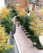
Photo courtesy Murase Associates |
Located in the heart of the downtown business core at Benaroya Hall, the half-acre Garden of Remembrance offers opportunities to reflect upon the citizens of Washington who gave their lives in the line of duty. The names of over 7,500 men and women are engraved in granite walls positioned to embrace the warmth of the western sun, surrounded by native plantings, falling water and artfully arranged stones. The garden, designed by LMN Architects and Murase Associates and completed in 1998, integrates the contextual needs of the city and serves as a civic plaza, attracting a sizeable lunch crowd on sunny summer days. The space also serves as an entry portal into the Metro bus tunnel.
Seattle Center, Fifth Avenue North and Broad Street
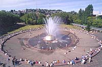
Photo courtesy Auston James/Seattle Center |
Home to the 1962 World’s Fair, the 74-acre Seattle Center is a focus of cultural and sporting activities and a number of festivals and events, such as Folklife Festival and Bumbershoot.
The center has over 9 million visitors annually. The original fair site was planned and designed by Seattle architect Paul Thiry and San Francisco landscape architect Lawrence Halprin, but many designers have been involved in ongoing development. In 1964, Richard Haag Associates designed a series of urban parks, featuring a diverse selection of plant materials throughout the grounds. In 1991, the Seattle Master Plan was adopted and since then Seattle Center has been in the throes of major redevelopment.
The Space Needle is perhaps the most recognizable symbol of Seattle, designed by Victor Steinbrueck for the firm of John Graham Jr., and built for the World’s Fair. Seattle Center’s open space also features the redesigned International Fountain (by Nakano-Dennis Landscape Architects) and recently completed Fisher Festival Pavilion (by Miller/Hull Architects).
Other major highlights include the Pacific Science Center (by NBBJ with Minoru Yamasaki & Associates); Key Arena, (originally designed by Paul Thiry and renovated by NBBJ); the Experience Music Project (by Frank Gehry); and the Center House (former armory building) with its food court.
The theater district along Mercer Street is undergoing a major facelift with the renovation of the Opera House (by LMN Architects). Seattle Center is also home to the Pacific Northwest Ballet and three theater groups. Visit www.seattlecenter.com for further information on the 5,000-plus events held there each year.
McGraw Square, Fifth Avenue and Stewart Street
|
One of the smallest parks in Seattle, McGraw Square is located near the Westin Hotel at the intersection of Fifth Avenue, Stewart Street and Westlake Avenue. The 0.1-acre square is named for Judge John McGraw who was an influential figure in early Seattle’s development.
McGraw worked as a Seattle police chief, harbor master, fire warden and King County sheriff — and served as governor. He was a strong proponent of linking Puget Sound and Lake Washington with a ship canal. Design of the square was influenced by the Olmsted Brothers’ park plan for the city, but the designer and date of completion are unknown.
Hing Hay Park, Maynard Avenue South and South King Street
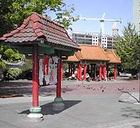
|
This urban park is a focal point for the International District. It features a red tile-roofed Chinese pavilion that was a gift from one of Seattle’s sister cities, Taipei, in 1975. On the wall of the Bush-Asia Center is a large dragon mural by artist John Woo.
The park, originally completed in 1973 and designed by Sakuma James & Peterson Landscape Architects, is used as a community gathering place and is home to several annual events and festivals, including the Seafair International District Summer Festival.
Olympic Sculpture Park, Western Avenue and Broad Street
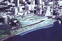
Photo courtesy Seattle Art Museum |
The public will soon be able to enjoy one of the largest open spaces in Seattle with the completion of the Seattle Art Museum’s Olympic Sculpture Park, designed by Weiss/Manfredi Architects with Charles Anderson Landscape Architecture.
Offering a flexible artistic program in a Northwest-inspired design, the new park will be located on the waterfront, just north of Pier 70. Currently, the planned centerpiece of the 8.5-acre park is Alexander Calder’s “Eagle” that soars more than 39 feet above the ground.
Constructed on a former industrial site, the park will also be home to landscape precincts that include an evergreen forest, open meadow and coastal plantings. Its Z-shaped design will connect three disparate sites, bringing art, people and landscape together while honoring the urban infrastructure that also characterizes Seattle’s downtown waterfront. Views of Puget Sound are a highlight, especially as the sun sets behind the Olympic Mountains. It is expected to be completed in 2005.
Civic Center, Fourth Avenue between Cherry and James streets
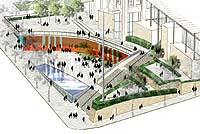
Photo courtesy Gustafson Guthrie Nichol |
The Civic Plaza is being built to create open space in the core of downtown Seattle. The 0.7-acre open space will extend from the west edge of the new Justice Center, through City Hall to Third Avenue.
The plaza, designed by Gustafson Guthrie Nichol and Swift and Co., is being designed to be an inviting gateway to City Hall, with places for intimate meetings, large public gatherings and community celebrations. Additionally, the plaza will provide views of Elliott Bay and the Olympic Mountains.
Waterfall Garden, Second Avenue South and South Main Street
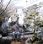
Photo courtesy Brooks Kolb |
Commemorating the birthplace of United Parcel Service in 1907, Waterfall Garden was completed in 1978 and designed by Sasaki, Dawson, DeMay. The high-style, urban outdoor room is enclosed by a tall, elegant ornamental iron fence.
The formality of this small space is contrasted with the naturalistic appearance of the waterfall, similar to those found in the nearby Cascade and Olympic mountains. This is an early example of an “eroded edge” between architectural and natural design elements which has become a significant theme in modern landscape architecture.
An intimate, oasis-like refuge for seating and a contemplative pocket park, Waterfall Garden is Seattle’s answer to the celebrated Paley Park in New York. While its 22-foot-high rock waterfall appears to be natural, it can also be viewed as a modern interpretation of a traditional Japanese garden.
Harbor Steps, University Street: First and Western
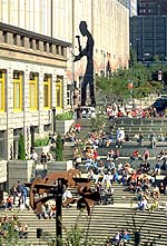
|
As a stairway promenade and an important path to Seattle’s waterfront and the business center, Harbor Steps is one of Seattle’s major open space parks. The stair-stepped fountains, plantings and southwest exposure make it a popular lunch spot. The steps offer amphitheater seating for Seattle’s free summertime concerts and other festivals. Post Alley intersects the promenade, for connections north to Pike Place Market and south to Pioneer Square. It was completed in 2000 for Harbor Properties, and designed by Arthur Erickson Architects and Hewitt Architects.
Occidental Park/Occidental Mall, Occidental Avenue and South Main Street
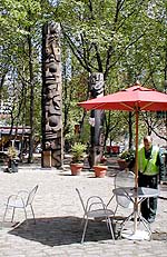
Photo courtesy Karen Kiest |
These adjoining spaces, totaling one acre in size, were designed by Jones and Jones and completed in 1972 to uphold the historic preservation of Pioneer Square and re-assert values of urban living and the urban environment. Cobblestones and ornamental iron light posts merge with modern design to create a refined atmosphere.
The mall is a tree-lined pedestrian street closed to traffic that features art galleries and restaurants. The mall has been designated a “green street” by the city of Seattle.
The park is used as a gathering space for concerts and leisure. Its glass shelter, which provides rain-protected seating, is a modern design that recalls the nearby Victorian pergola in Pioneer Square. Four totem poles carved by Duane Pasco were donated in 1985 by developer Richard White, a long-time resident of Pioneer Square. The park was renovated in 1987 by the Seattle Department of Parks and Recreation.
Freeway Park, Sixth Avenue and University Street
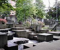
Photo courtesy Karen Kiest |
Freeway Park was designed in part to serve as a “bridge” between First Hill and downtown when Interstate 5 severed the two districts in the 1950s. Designed in the office of Lawrence Halprin and completed in 1976 as part of a lid over the freeway, the 5.2-acre park is located near the Washington State Convention & Trade Center, where Sixth Avenue intersect University and Seneca streets.
The park is noted for its concrete walls representing canyons, small intimate spaces and waterfalls that diminish freeway noise. Overall, the park is a linear series of spaces that connects the convention center and downtown Seattle. It serves as a destination where residents, shoppers, downtown office workers and hotel visitors intermingle.
Don Benson is a senior planner and landscape designer at URS and past president of WASLA. He oversaw the Seattle Downtown Urban Landscape Guide project. WASLA was established in 1973 and includes about 330 members in Washington.
Other Stories:
- Another scenic century
- Weaving stories into a living corridor
- Telling the story in the land
- Landscape architects adapt to changing world
- To stand at the edge of the sea
- Transportation and landscape design
- Olympic Sculpture Park: a Northwest collage
- Growing urban oases
- Volunteers build community
- Celebrating sustainable water systems
Copyright ©2009 Seattle Daily Journal and DJC.COM.
Comments? Questions? Contact us.