
Surveys
DJC.COM
April 22, 2004
Landscape connects rivers and cultures
Jones & Jones

Senos
|
This small hub in Vancouver has radiated major pulses of activity extending across continents, oceans and several generations. American Indians journeyed the Klickitat Trail to the site, a trans-Cascade network of trails and prairies that connected the native peoples' subsistence areas and enabled the diverse bands to congregate and trade along the Columbia River.
Lewis and Clark stopped by during their 1805-1806 expedition and encountered a resident American Indian population that doubled from 5,000 to 10,000 during the salmon spring run. Their journals describe the Indian-burned prairies on site, and the intrepid explorers named the Vancouver-Portland area “Wapato Valley” after the tribes' primary root crop.
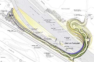
Rendering courtesy of Jones & Jones
The Land Bridge will reinstate connectivity to the river’s edge and create a gateway to the city of Vancouver. |
Two decades after the Corp of Discovery's expedition, the Hudson Bay Company established Fort Vancouver, the trading center of the Pacific Northwest. United States gained control of the Northwest territories and built a military reserve on location, an active post for nearly 200 years. Fort Vancouver participated in all major wars and operated the world's largest spruce mill and Kaiser Shipyards. Pearson Airfield, also located on site, ushered in the Golden Age of Flight and is the nation's oldest continuously operating airfield.
The Columbia River is the common thread through time that stitches the varied historic events into one dynamic story. The Columbia shaped the floodplain landscape, directing the course of landscape and social developments on the Vancouver site. Unfortunately, the crippling of the Columbia, and the construction of transcontinental railroads and highways along the river's edge disrupted the land-river connection.
This disconnect was addressed in recent plans prepared by the National Park Service and Jones & Jones, which identified the vital characteristics that contribute to the historic site's integrity, and provided clear direction for ongoing management. The planning documents, the Fort Vancouver National Historic Site Draft General Management Plan and the Vancouver National Historic Reserve Cultural Landscape Report, both strongly recommended a new pedestrian bridge to reconnect the place to the river.
Daunting political complexities and the site's physical constraints would suggest that this bridge concept was a pipe dream of wishful planners. But the idea captured the imaginations of the proponents for the Confluence Project.
Envisioning the Columbia through art and place
The Confluence Project is the celebration of art, place, culture, history and potential futures for the Columbia River. It represents the partnership of the Lewis and Clark Commemorative Committee of Vancouver-Clark County, the Friends of Lewis and Clark of Pacific County, the Confederated Tribes of the Umatilla, the Nez Perce Tribe, the Chinook tribes, and many other dedicated groups and individuals.
Through a series of public artworks, the Confluence Project will commemorate the Columbia River people and landscape at the time of contact with Lewis and Clark, and will provide a vision for healthy land-culture interactions in the future. Construction is slated to correspond with the Lewis and Clark 2006 Bicentennial celebrations.
Artist and architect Maya Lin and architect Johnpaul Jones helped the Confluence Project select the sites within the Columbia and Snake basins that mark important convergences of rivers and cultures.
It is anticipated that seven interpretive sites will be developed, five in Washington and two in Oregon. Examples of confluence locations are: the Clearwater and Snake rivers confluence (Nez Perce, Clarkston); the Snake and Columbia rivers confluence (Confederated Tribes of the Umatilla, Pasco); near the Columbia and Willamette rivers confluence (Chinook Nation, Vancouver), and the Columbia River mouth (Chinook Nation, Pacific County).
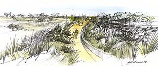
Drawing by Anita Lehmann
Land Bridge pedestrians will experience an interpretive journey through the area’s landscape and culture at the time Lewis and Clark encountered the Columbia River and its people. |
Lin, known for her emotionally provocative creations such as Vietnam Veterans Memorial and the Civil Rights Memorial, will design artwork installations for the confluence sites. Each artwork will be distinct but will tie into the larger theme of “a meeting of rivers and cultures” at the time of Lewis and Clark's journey.
Bridging land and people to the river's edge
Vancouver National Historic Reserve will host the largest artwork, the Land Bridge. Jones & Jones developed the Land Bridge design concept in collaboration with Lin, the Confluence Project, the city of Vancouver and the National Park Service. The landscaped pedestrian bridge will physically connect the historic Vancouver site to the Columbia River by pulling the land up and over the transportation barriers to reunite people and land with the river.
The Land Bridge concept draws upon nature's organic forms and the Native American significance of the circle, which symbolizes continuity of life and the cycles of nature. It also evokes the historic evolution of the site, and the significant cultural bond to the Columbia River. The Land Bridge will present pre-settlement landscape conditions and interpretive work by Lin to recount this historic crossroads encountered by Lewis and Clark.
The concept calls for a 40-foot-wide, earth-covered land bridge that restores the landscape and social connection to the river while establishing a civic landmark and gateway to the city of Vancouver. Sweeping across the highway in a simple but elegant arch form, the bridge will help reinstate the natural landscape continuum from upland forest to riparian edge.
A pedestrian path will meander up and over the bridge through native plantings and undulating landforms that respond to floodplain terraces and their corresponding vegetative systems. It will tie into historic circulation routes such as the Klickitat Trail and Hudson Bay Company roads.
Visual access is a key component to the design and the site's history. The U.S. military strategically established Officer's Row on the upper floodplain terrace, which offered sweeping views to the river. Pedestrians on the Land Bridge will be afforded two primary interpretive overlook opportunities: one facing toward land and Fort Vancouver, and the other oriented toward the Columbia River and riverfront development. Thus, visitors will have the opportunity to appreciate the historic sense of place spanning from Native American influence to present activities, while reflecting on our current relationship to the Columbia River.
The project is quickly moving into final design. This spring, the city selected engineer KPFF and Jones & Jones to develop final design plans for the Land Bridge, with an ambitious targeted construction date of 2005. KPFF and Jones & Jones will continue to closely work with the Confluence Project, the city, the National Park Service, the tribes and other stakeholders to implement a project that bridges diverse stories and values related to the Columbia River cultural landscape.
The Land Bridge is not intended to be just another built object in the landscape already filled with too many built objects. The life it celebrates will be the land that is carried across to its lost river relative, the prairies and cottonwoods, and the memory of the river-carved terraces. The life will be the people who congregate, celebrate, and relate their own selves to cultures and landscapes seven generations forwards and backwards.
And for the people who come to the Land Bridge, it will be a true convergence, a confluence of historic encounters and potential futures on the Columbia River.
Rene Senos is an associate at Jones & Jones Architects and Landscape Architects.
Other Stories:
- Gardeners go trowel to trowel in contest
- What is your landscape telling you?
- Seattle's big chance to reconnect the waterfront
- Keeping runoff out of sight, but still in mind
- Ecological restoration goes beyond trees and shrubs
- Amgen unwraps the landscape at Helix
- Landscape designers promote active lifestyles
- Low-allergen landscapes nothing to sneeze at
- The do's and don'ts of planting new trees
- Shared streets can provide open space, too
- Art meets Frisbees in north Seattle park
Copyright ©2009 Seattle Daily Journal and DJC.COM.
Comments? Questions? Contact us.