
Surveys
DJC.COM
April 18, 2002
The street becomes a stage: New roles for roads
GGLO
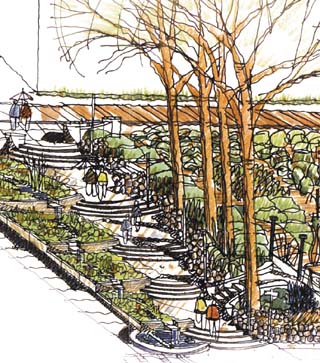
Carlson Architects sketch of the cistern steps at Vine Street between Western and Elliott. |
The list of roles they are expected to fulfill includes: connector, spacer, organizer, way-finder, artery and storage, to name a few.
They are the shared social spaces that define the American city as we know it. And in our ever-increasing demands on them, we’re starting to consider them in another light: as a real estate extension and a stage. In order to capture the most potential benefits, and market appeal, streets at many new urban projects are being defined with a complexity that recalls theatrical set design.
In Western Washington, new and old streets are being conceived as changeable, programmable public places that must and can do many things at the same time.
The design challenges are as particular as the locale in which they each take form. For the small city of Bellingham, an old, too-wide street that left a blank in an emerging downtown neighborhood is being redesigned to fill it with life.
In north Kirkland, on the east side of Lake Washington, a new development conquers the suburban superblock with a new street, and in downtown Seattle a vigorous citizen effort is changing the way a downtown street collects, uses and enjoys stormwater.
Bellingham’s Railroad Avenue
When a railroad abandoned its tracks on the bluff above Bellingham Bay, the city found itself with a 130-foot-wide right-of-way cutting through an historic, low-density commercial neighborhood of stores, warehouses and small business.
Courtesy of GGLO Bellingham’s Railroad Ave. has been redesigned as a 64-foot-wide “amenity zone.” |
Twenty-five years ago the street was configured into a bonus space for surface parking and circulation which well served the local district then. Now the city and the community are searching for a new face for the street.
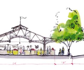
While preserving much of the 200-stall-per-block parking, they want a gateway, stroll street and permanent home for the Bellingham Farmer’s Market.
The Landscape and Urban Design Group at GGLO looked at market streets around the world and took inspiration especially from Stockton-on-Tees High Street in the northeast of England — childhood home of GGLO principal, Alan Grainger — where the street has been a Saturday market every week for the past seven hundred years.
In a concept study now on the boards, a reconfiguration of the Railroad Avenue right-of-way has redefined the street as a sixty-four-foot-wide “amenity zone,” bounded by two lanes of traffic and parking.
The linear amenity zone carries an interchangeable set of parts and pieces. These additive pieces of stage settings are: mini-parks, twelve-car mini-lots, modular open-air market buildings that accept cars on non-market days and an urban forest which is the backbone of each of the parts.
All of the parts fit together in a repetitive pattern down the street.
The amenity zone concept has something for everyone; copious parking, pocket parks, farmer’s market, bike lanes, tree buffers and, of course, a major new stroll street.
It is anticipated that the street, so configured, will boost new retail and housing development, allowing the city to recoup its investment.
Juanita Village
For the new Juanita Village mixed-use development, carving a good street out of a suburban superblock was the mission of the designers at GGLO and the Berger Partnership. The street will be called Northeast 96th Place, and the concept grew out of a zoning code requirement for a view corridor across the eleven acre site.
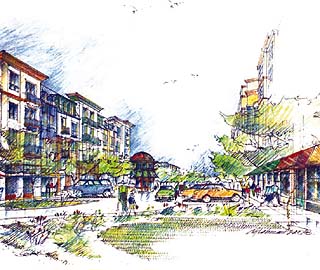
Courtesy of GGLO Site plan and sketch of Northeast 96th Place in Juanita Village.
|
The designers turned the view corridor into a multi-purpose street, oriented it toward Lake Washington and lined it with small retail shops and front stoops.
At each end is a public plaza with art and within the inner plaza is a great wading pool. All of this is directed toward taming the superblock while creating a new high-density mixed-use neighborhood in the suburbs.
The street acts as an ordinary vehicle circulator with parking, a sheltered pedestrian connector to Juanita Park, an urban festival space and a traffic-calming device.
Two aspects of the concept are particularly important to the future of high-density neighborhoods: first, the street is privately owned and maintained but assured for public use with a public easement.
Second, the street breaks down the normal super block scale with a lively, green place, diffusing traffic throughout the neighborhood. It effectively increases local traffic options while increasing retail frontage simultaneously.
Growing Vine Street
In downtown Seattle, a vigorous resident group, led by local architect Carolyn Geise, is working through all of the issues related to reversing the way stormwater is handled on one street in the city.
The Growing Vine Street Project was launched originally to capitalize on exceptional community success with establishing the Belltown P-Patch. Vine Street, which borders the P-patch, was a designated but unimproved ‘green street’ in the downtown pattern, where parks are few and far between.
The community set out to create a model street, posing the question of how to help the city address issues of wise water management for the new millennium, while creating a street park in Belltown.
Though a master concept for the whole street was prepared by the team of Carlson Architects with artist Buster Simpson and landscape architect Peggy Gaynor, the steering committee decided to build the first link in the plan in the one block adjacent to the P-patch itself.
Called the Cistern Steps, this new public development in the Vine Street right-of-way between Western and Elliott was designed by the Carlson Team and SvR Design.
IntraCorp’s new housing project at Western and Vine, designed by GGLO, generously supplied the roof water needed to activate the whole Cistern Steps recycling process.
The steps themselves are a grand-scale public gathering place which is brought alive by rainwater, forming a wetland garden. Since the water will be available during the normal rainy season only, the gardens will sustain plants which are perfectly acclimated to our Northwest water regime.
The value of this is twofold, educational and aesthetic. It is intended that the gardens at the Cistern Steps will help Seattleites rekindle an appreciation for our native plant palette while appreciating the natural resources handled by the city day in and day out.
Barbara Oakrock is a landscape architect and senior associate at GGLO.
Other Stories:
- Greenbacks in the greenery
- Blending scenery and ecology
- Gorillas help build their new Hawaiian home
- Healing gardens take many forms
- An evergreen manifesto
- Finding an identity in the forest
- Lifting our sights beyond ‘our’ sites
- Volcanic legacies
- Collaborating from the ground up
Copyright ©2009 Seattle Daily Journal and DJC.COM.
Comments? Questions? Contact us.