
Surveys
DJC.COM
April 18, 2002
Volcanic legacies
Otak
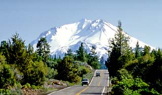
Photo courtesy of Otak Mount Shasta is one of the crown jewels of the Volcanic Legacy Corridor in “upstate” California. |
Often, they lie shrouded beneath the clouds and hidden from view. Then, suddenly, the weather will clear, and one of the mountains will mysteriously appear in full view, treating Northwesterners and visitors alike to an awe-inspiring encounter. Many can be heard to gasp: “The mountain is out ... the mountain is out!”
The Cascades offer a wide array of experiences for all different types of explorers, those seeking to climb and conquer each peak, as well as those preferring to gaze at these scenic wonders from afar. Even the most intrepid of adventurers appreciate the splendid views of the conical volcanoes, including Meriwether Lewis and William Clark, who traveled through this region nearly 200 years ago.
Otak’s work on the scenic byways that lead to various Cascade peaks will help to enhance and preserve the unique qualities that surround the mountains, enriching the journeys of visitors, as well as the lives of the people from the surrounding communities.
Gateway to Mt. Rainier
At 14,411 feet, Mount Rainier is the highest of the Cascade volcanoes and serves as the backyard playground to those living in the urban areas of Puget Sound. Millions of people visit Mount Rainier National Park each year. One of the major challenges faced by the National Park Service and the communities that surround the mountain will be accommodating increasing numbers of visitors over the long term, while also preserving and protecting the scenic beauty of Mount Rainier and the natural landscapes that surround it.
Otak recently completed a feasibility study for a new welcome center to be located in Enumclaw. The potential gateway center for Mount Rainier will be a “first stop” on the way to the mountain for visitors. Travelers will be able to learn about its dynamic natural history and the delicate environment that surrounds it.
Promoting Enumclaw as a gateway to Mount Rainier makes ecological sense because it helps to ease visitor concentrations at the popular southwestern entrance and disperse visitor impacts and associated management activities.
Gateway communities like Enumclaw offer the benefit of visitor services and accommodations (restaurants, lodging, restrooms and information), reducing demand for these facilities within the park as visitation grows. Also, visitors can be shuttled to the park from the outside gateway centers, reducing traffic congestion and air quality impacts.
Interpretive exhibits at the Enumclaw Welcome Center will enable visitors to learn more about Mount Rainier’s volcanic geology and the history and cultures it has influenced throughout the region. Travel information and map displays will help guide visitors to managed recreation areas. Once travelers are oriented, they can drive to the national park or other area destinations surrounding the mountain — or park their car and catch a tour bus.
Volcanic journey
When Lewis and Clark traveled through the Pacific Northwest, they were astounded by the beauty of the Cascade peaks. At the time, they didn’t realize these mountains were active volcanoes. To the explorers of the Lewis and Clark Expedition, the snow-capped conical mountains were a welcome sight and important landmarks for orienteering.
Lewis and Clark had studied the maps of Captain George Vancouver, an earlier explorer who had traveled along the Pacific Coast a few years before and charted several of the mountains. After many months of traveling through uncharted territory, the expedition finally came within view of these peaks and knew they were once again “back on the map.”
On Oct. 18, 1805, William Clark wrote that he “saw a conical mountain bearing southwest, covered with snow.” Lewis and Clark referred to the Cascade peaks many times while traveling through the region, and they knew that as Mount Hood and Mount St. Helens came closer into view, they were nearing their primary destination and the object of their mission, the Pacific Ocean.
After catching a sublime view of Mount St. Helens in its pre-eruption state nearly 200 years ago, Meriwether Lewis described the peak as “the most noble looking object of its kind in nature. Its figure is a regular cone perfectly covered with snow.” William Clark wrote that “it rises something in the form of a sugar lofe.” Indeed, the near-perfect conical form of Mount St. Helens was forever changed by its catastrophic eruption in 1981.
Otak is currently planning and designing various interpretive exhibits and visitor improvements at state parks and other sites along the Lewis and Clark Trail throughout Washington. These projects will create educational and recreational opportunities for the many visitors who will come to the region for the national commemoration of the Lewis and Clark Bicentennial in 2003 through 2006.
The interpretive exhibits and site improvements will create a lasting legacy along the national historic trail, to be cherished for generations to come. Interpretive themes for the exhibits along the trail will not only educate travelers about the history of the Lewis and Clark Expedition, but also enlighten them about the perspectives of the native peoples the expedition encountered.
A major goal of the interpretation is to honor the native cultures of the region, as well as to convey important messages about stewardship and environmental considerations.
Scenic byway
The Volcanic Legacy Scenic Byway extends from Crater Lake National Monument in Oregon to Lassen Volcanic National Park in “upstate” California. Travelers of the scenic byway are treated with many experiences, including vast wetlands and wildlife refuge areas, as well as majestic views of Shasta and Lassen peaks.
In 1996, grass roots citizen interest, supported by the resources of multiple agencies throughout northern California and southwestern Oregon, originally conceived the idea of a two-state scenic byway. This concept grew into the “Volcanic Legacy Scenic Byway,” a route that celebrates the nation’s premier volcanic landscape, as well as the vast recreational and tourism opportunities and the unique scenic beauty the region offers. Mount Lassen, the southernmost volcano of the Cascade Range, provides a fitting terminus for this byway — one of the of the most unique routes in the country.
Otak recently completed work on the Volcanic Legacy Corridor Management Plan for the California portion of the scenic byway. The study inventoried existing conditions along the corridor, including those related to important national destinations such as Lava Beds National Monument, Mount Shasta and Lassen Volcanic National Park.
The plan summarizes the visions and goals that many of the local communities and agencies in the region have for the byway, including recommendations for ongoing management and preservation of the unique resource areas, as well as recommendations for visitor facilities and interpretive themes.
The volcanic geology of the region — including the visible features of volcanic systems such as lava flows, cinder cones, ice caves, obsidian flows, lava tubes and other elements — will be highlighted in the interpretation along the byway. Interpretation will explain how the present features were formed and how the area may change in the future.
Otak also assisted representatives for the California portion of the byway in preparing an application for “National Scenic Byway” status, and specifically for the “All-American Road” designation — the most prestigious of all national byway categories. Byway enthusiasts eagerly await a decision from the Federal Highway Administration, which should be forthcoming later this summer.
Mandi Roberts is a principal and lead landscape architect at Otak.
Other Stories:
- Greenbacks in the greenery
- Blending scenery and ecology
- Gorillas help build their new Hawaiian home
- Healing gardens take many forms
- An evergreen manifesto
- Finding an identity in the forest
- The street becomes a stage: New roles for roads
- Lifting our sights beyond ‘our’ sites
- Collaborating from the ground up
Copyright ©2009 Seattle Daily Journal and DJC.COM.
Comments? Questions? Contact us.