
Surveys
DJC.COM
April 10, 2003
Transportation and landscape design
Cascade Design Collaborative
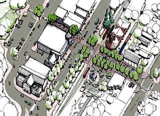
Courtesy of Cascade Design Collaborative The central business district of Snoqualmie will accommodate fast and slow traffic with a “three-way triplet.” |
From road to sidewalk to rail, getting there should be easy and fun. In small historic towns and large urban areas, that means preserving and building safe, exciting spaces that are great for shopping, strolling — or simply driving through.
Scale is used as the framework for creating these spaces, whether the project needs to accommodate a few or a few thousand, or be recognizable at 5 or 50 miles per hour. Urban landscapes and streets must work at different scales, for pedestrians and vehicles.
Sight is a way for people to experience different scales. We are constantly taking visual cues from our surroundings for decisions such as where to shop, park or cross a street.
Cascade Design Collaborative studies a range of sight-related issues for both pedestrians and drivers, including those related to development aesthetics and parking visibility.
State Route 202 through Snoqualmie — from 0 to 50 miles per hour
State Route 202 runs through the historic town of Snoqualmie. Cascade Design helped the state Department of Transportation balance future roadway capacity, speed and safety needs with the desire for improved parking, pedestrian accessibility and non-motorized trails.
The small town‘s limited street grid, severely restricted right of way, its historic buildings, an existing railroad facility and the natural features of the adjacent Snoqualmie River created unique constraints on developing the right solution.
Our greatest challenge was to find relationships between pedestrians strolling at 3 miles per hour, bicyclists and shoppers looking for parking at 5 to 15 miles per hour, local traffic moving at 20 to 30 miles per hour — and those commuters wishing to return to 50 just as soon as possible — all in a very constrained built environment. Visibility issues for roadway safety and for parking and retail storefronts became the “common ground” for finding the right-of-way design.
Based on these issues, we challenged typical solutions that involve one-way couplets with off-street parking, and proposed a “two-way triplet.” The idea was to use three parallel two-way roadways to achieve future capacity needs without widening the roadway and thus impacting the historic features of the downtown area. This solution includes three street use types: one for local commercial activities, the second for retail activities and the third for tourist and through traffic. Roundabouts, on-street parking, creative channelization and streetscape amenities will improve visibility, safety and shopping opportunities.
The end result will disperse the future traffic demand onto all three streets, improving the visibility needs for drivers at varying speeds — including shoppers — while preserving the existing historic two-way street grid. Existing businesses will remain, and the character and scale of the historic town will be preserved.
Tacoma Dome connections — for groups of 10 to 10,000
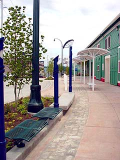
Courtesy of Cascade Design Collaborative Sidewalk paving and street amenities connect urban development near the Tacoma Dome. |
In the urban environment, we are often confronted with a spatial paradox. Walkways must feel inviting and comfortable to individuals and daily shoppers, yet accommodate heavy volumes of traffic.
At what point do parking lots or streets feel too empty or too full, sending a message to shoppers inviting them in or turning them away in frustration? Too much street furniture in a plaza or along a sidewalk can create a sense of emptiness when crowds are not present, and can also create friction and inefficiencies when large crowds are present.
These were some of the questions facing Pierce Transit and the city of Tacoma when they hired Cascade Design to design an inviting and safe pedestrian environment and streetscape network; a system that tied together all of their transit and parking facilities in the Tacoma Dome area. Streets, sidewalks and urban plazas must serve daily activities and accommodate surges of up to 10,000 patrons for events at the dome.
The first stage of the project began in the 1990s with the creation of the Tacoma Dome District Plan. A team of urban designers and traffic planners established a series of transit facilities — most of which are now in place — including Pierce Transit’s bus and parking facility, the Link light rail to the downtown and the Sounder train to Seattle.
Together, these transit functions have reduced the demand on parking and acres of asphalt are slowly disappearing, being replaced by retail and event facilities.
Cascade Design’s design challenge, to determine the “right size” for the street grid, was addressed through the redesign and resizing of streets, sidewalks and parking areas. Dispersed points of transit and parking access allowed the sidewalks and street widths to remain in-scale with the neighborhood. Multiple paths of movement spread concentrated pedestrian traffic during events, reducing potential conflicts with cars at intersections. Easily accessible street parking and clear, convenient access points to adjacent parking structures were also critical design elements.
The design of the sidewalks and street amenities complete the complex urban puzzle and provide the “glue” that connects the larger elements and redefines the atmosphere of the area. Amenities included formal elements such as benches and bus shelters as well as natural features. Sculptural elements were designed to play a duel role for crowded and daily conditions.
In the future, the continued subdivision of larger industrial urban blocks into smaller networks of interconnected public walkways and private arcades will complete this renewal process. The creation of this network can be facilitated in alleys with urban activity, unlocked backdoors and well maintained dumpsters.
The scale and variety of these pedestrian connectors, that offer opportunities for movement, will determine the success and future growth of this pedestrian retail and civic event area.
The monorail meets the street — from 20 square feet to 20 square miles
During phase one of urban planning and design for the Seattle Monorail, Cascade Design studied the project at both micro and macro scales.
Issues addressed at a micro scale included the pedestrian environment directly affected by the guideway columns. The macro scale included the neighborhood through which the guideway would pass. This integrated process insured that in guideway placement, the needs of the individual pedestrian, who is most conscious of the 20 square feet nearby, would balance the collective needs of each of the neighborhoods along the 20-square-mile area of the corridor.
In the process, Cascade Design analyzed geographic information system (GIS) data for the entire 14-mile Green Line corridor — slopes, hazard areas, historic building zoning, land use value, utilities, roadway rights of way and traffic, bus routes, truck routes, etc. — to identify various routes for the monorail that best supported the existing city/neighborhood plans, existing land uses, and other infrastructure functions already in place in Seattle. These variables were overlaid with recent aerial photographs of the corridor to effectively and efficiently identify potential routes.
At the same time, we assessed the urban design issues and opportunities for the pedestrian/street environment along the various roadway corridors. Sun angles, views to and from the system, street widths, building and storefront activities, zoning, proximity to public facilities, distance to other transit stops, parking, traffic and pedestrian movement were all part of the mix.
The interrelationship between the two scales of information would ultimately define conflict points and limit the number of route options. The GIS analysis began at the larger neighborhood area and eventually focused down to a block-size assessment. While the urban design analysis began at the overall street corridor and focused down to 20 square feet area at the columns location.
Cascade Design built prototype station concept models to test column and sidewalk issues, and sketched street sections to identify traffic, pedestrian, land use and property problems. These tools let the differing scales begin to shape the project.
Embracing the scale of space and speed and designing visual cues at all of these levels creates dynamic and active places. From trails to pedestrian plazas to monorails, getting from place to place should be simple and enjoyable.
Eric Schmidt is principal of Cascade Design Collaborative.
Other Stories:
- Another scenic century
- Weaving stories into a living corridor
- Telling the story in the land
- Landscape architects adapt to changing world
- Seattle’s best outdoor spaces
- To stand at the edge of the sea
- Olympic Sculpture Park: a Northwest collage
- Growing urban oases
- Volunteers build community
- Celebrating sustainable water systems
Copyright ©2009 Seattle Daily Journal and DJC.COM.
Comments? Questions? Contact us.