
DJC.COM
August 9, 2001
Earth-shaking discoveries impact design
Shannon & Wilson
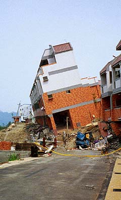
Photo courtesy of Shannon & Wilson The 1999 Chi-Chi earthquake in Taiwan, magnitude 7.6, caused vertical ground surface ruptures of up to 30 feet — similar to what could be expected on the Seattle Fault anywhere between Bremerton and Issaquah.
|
Consider the quandary faced by contractors and builders throughout the Puget Sound area these days.
Discoveries in just the past few years indicate the ground beneath us is even more fractured with even more seismic formations than we thought previously. It seems that new faults are being located every year. Known faults once considered inactive and not extending to the ground surface are now believed to be active, sometimes rupturing the surface in unexpected places.
Paradoxically, our state decided not to adopt new building codes that would require more stringent seismic design in the Puget Sound region. The building code is typically revised nationally every three years, but adoption is up to individual jurisdictions. The 2000 revision boosted design requirements from a 500- to 2,500-year seismic event. Washington opted to stick with the 1997 code.
The result? Although scientists uncover new evidence of seismic activity around Puget Sound all the time, builders are only obligated to incorporate design elements for lower hazard levels compared to other states that have adopted the revised 2000 code.
In the absence of the newer, more stringent code, owners must evaluate relative risks for themselves — and weigh short-term costs against the long-term likelihood of “The Big One.” The latest data makes for difficult choices.

Perkins |
Why the years matter
There’s a huge difference between earthquake ground motions with 500- and 2,500-year recurrences. The former refers to a quake with a 10 percent chance of occurring in 50 years. An example is the recent Nisqually quake of magnitude 6.8. Although the quake was a “subdesign” event, meaning that ground motions were generally smaller than required for current design, it still caused plenty of damage. Repairs continue today on the Legislative Building in Olympia, the Sodo Center and the Alaskan Way Viaduct.
Imagine what could happen during a 2,500-year quake, with only a 2 percent likelihood of occurrence every 50 years. In Western Washington, effects will likely be catastrophic in nature, as illustrated by the 1995 quake in Kobe, Japan (magnitude 7.2) and the 1999 Taiwan quake (magnitude 7.6). Major events like these can devastate entire cities, as they feature larger ground motions that last for a longer duration.
Slip-sliding on plates
We have not had a quake large enough to produce 2,500-year ground motions here in recorded history. But geological evidence suggests that large earthquakes capable of generating these strong ground motions have occurred in the past and are expected in the future.
Geologic evidence indicates that large interplate quakes on the Cascadia Subduction Zone off the Pacific Northwest coast occur about every 600 years (actual recurrence intervals range from about 300 to 900 years), with the most recent one about 300 years ago. Historical Japanese documents report 10-foot-high tsunamis hitting the islands on about Jan. 26, 1699, with the apparent source being a monumental event on our coast. This event is estimated to have been a magnitude 9.0.
Should Seattle-area engineers bet on an interplate disturbance here in the next century? Yes, but we can’t say whether it will happen tomorrow or 600 years from now.
The location of a rupture will be a huge factor in potential damage. An interplate earthquake is generally anticipated along the coast. But we don’t know how far inland the rupture area could extend. Since Seattle is more than 100 kilometers from the coast, a rupture that was contained offshore would have fewer effects on us. However, the farther inland the rupture extends, the closer it comes to greater Seattle — and the greater the potential for ground shaking.
Not just Seattle’s fault
Recent research on the Seattle Fault indicates another set of disturbing possibilities. The Seattle Fault runs between Bremerton and the Sammamish Plateau, right underneath Seattle along I-90. Until the 1990s, the fault appeared inactive, and was not believed to extend to the ground surface.
We now have geologic evidence that ground rupture and large earthquakes have occurred on the fault multiple times in the last several thousand years. The most recent large event was about 1,100 years ago, and it thrust the ground up 22 feet in some places on the south side of the fault. The seismogenic potential of other faults and structures beneath Olympia, Tacoma, Whidbey Island, north King/south Snohomish counties and Hood Canal, long assumed inactive, are being re-evaluated too.
Not only are we finding evidence of geologically recent movement on the Seattle Fault, but researchers have also learned that the Seattle Fault consists of a number of splays in a zone up to 4 to 6 kilometers wide. Some of these splays have ruptured the ground surface. Unfortunately, these newly identified splays are appearing in densely populated areas. Engineers typically ignored implications of potential surface rupture from faults like these in the past. Not any longer, especially when considering 2,500-year design events.
How all of this affects developers
Some local jurisdictions like Bainbridge Island are already taking Seattle Fault ground surface rupture into account. The city is requiring developers in areas of known or likely ground rupture to identify where the fault cuts the ground surface. This is now possible using the results of airborne laser imaging and recent fault trenching studies by the U.S. Geological Survey. Once the deformation zone is identified, developers must maintain a building setback.
Comparable action could be expected in Seattle, Tacoma, Olympia and other local communities as faults become better mapped — and as ground ruptures continue to appear at the surface — regardless of code requirements at the state level.
The bottom line for developers
Builders are understandably hesitant about designing for large-scale earthquakes due to cost. While nobody knows exactly how much a building’s price tag would go up, increases could easily run between 5 and 20 percent. Is the amount of risk reduction worth the cost? For an interesting perspective, think of the numbers in reverse. If we have only a 2 percent chance of a 2,500-year event occurring in 50 years, we also have a 98 percent chance that it will NOT occur.
In other states, the odds are easier to justify. California has such frequent seismic activity that relative increases in design ground motions (and costs) are often not significantly different between 500- and 2,500-year events.
Washington is in a different league. Our large earthquakes are relatively few and far between. But when they happen, they can be just as devastating as California’s worst quakes.
The onus for making wise seismic design decisions currently rests with owners. It may not be for long.
Newer national building code recommendations may go un-adopted for three years, or perhaps even six. Our state certainly cannot hold out against national norms forever.
The issue, then, is not whether we start designing every new structure with a 2,500-year quake in mind. Like the Big Earthquake itself, more stringent code requirements are probably only a matter of time.
Bill Perkins, a registered geologist in Oregon, is senior principal engineering geologist at Shannon & Wilson, a Seattle geotechnical and environmental consulting firm.
Other Stories:
- The future is looking UP
- Urban form gets its roots from nature
- Downtown becomes a shopping mecca
- The scoop on infill development
- Infill problems? Get creative
- Rubbernecking leads urban retail revival
- Rx for Seattle’s growing pains: Collaboration
- DSA puts a downtown neighborhood on the ‘Edge’
- Public places — look between the buildings
- A blast from the past — modernism is back
- Getting the ball rolling with affordable housing
- Energizing Everett
- Urban development versus the public process
- Protecting views makes sense from every angle
- Urban development picture includes artists
- Pricing gridlock out of the market
- Retail? Start with the first floor
Copyright ©2009 Seattle Daily Journal and DJC.COM.
Comments? Questions? Contact us.