
Surveys
DJC.COM
July 25, 2002
A trail of mining waste turns into a trail of recreation
Special to the Journal
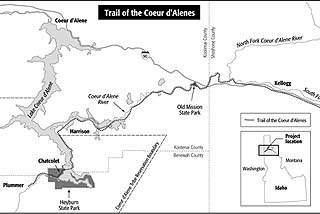
Map courtesy of Ridolfi Engineers |
What was for nearly a century the primary transportation route for the millions of pounds of mineral concentrate produced in the Silver Valley Mining District has been transformed into a destination recreational trail for residents and visitors to the Coeur d’Alene Basin. The trail spans the Idaho Panhandle from near the Montana border to the west side of Lake Coeur d’Alene to the Coeur d’Alene Reservation, near the Washington border.
Railroad history
Silver and lead were discovered in 1885 at what would become the Bunker Hill Mine in Kellogg, Idaho. By the following year, the first narrow-gauge rail line was built up the South Fork of the Coeur d’Alene River to Wallace to provide the needed transportation.
|
The mines in the area boomed with the year-round transportation route provided, but the narrow-gauge line was soon replaced with standard-gauge line.
In 1981, the Bunker Hill Co. shut down and in 1993 the last trains ran through the region. The state and Coeur d’Alene Tribe applied for a certificate of interim trail use needed for the recreational trail. The certificate and track salvage by the Union Pacific were approved by the Surface Transportation Board in June 2000.
The trail is being constructed in three counties, Shoshone, Kootenai and Benewah, along the former Wallace-Mullan Branch of the Union Pacific Railroad. The Wallace Branch runs about 64 miles from Plummer Junction to Wallace. The Mullan Branch includes about 7 miles of right of way from Wallace to Mullan.
Cleanup and restoration
Through the Superfund program, the Coeur d’Alene Tribe and federal natural resource trustees (U.S. Department of Interior and U.S. Forest Service) in cooperation with U.S. EPA, the state of Idaho and Union Pacific, evaluated cleanup alternatives of the metals-contaminated right of way. The group negotiated a unique settlement to convert the rail line to a trail with the primary objective of protecting human health and the environment.
The cleanup actions included removal of mine waste on the reservation, in residential areas, and in “oasis” areas designated for numerous rest stops along the trail. Several hundred thousand tons of mine waste and metals-enriched soils were removed from the right of way. Any remaining metals in the railbed are contained beneath the asphalt trail surface.
Placement of gravel parking areas and vegetated barriers and management of the right of way as a recreational trail are included in the cleanup plan.
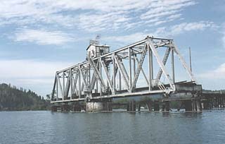
Photos courtesy of Ridolfi Engineers The trail will cross a historic swing-span trestle bridge at the southern end of Lake Coeur d’Alene.
|
Restoration efforts include upgrading numerous bridges to accommodate trail use and historic preservation of a unique 224-foot through-truss swing-span at the southern end of Lake Coeur d’Alene. Built in 1921, this swing-span and wooden-trestle bridge is believed to be the only movable bridge remaining in Idaho, and is eligible for the National Register of Historic Places. The new design will restore and incorporate the swing-span structure into a 3,000-foot-long fixed-span bridge over the southern end of the Lake.
Unique sights and culture
The trail is relatively flat — rising only 800 feet in its 72-mile length — and it opens access to beautiful areas of the Idaho Panhandle previously inaccessible to the public. The Coeur d’Alene Basin encompasses the Bitterroot Mountains along the Montana-Idaho border to Lake Coeur d’Alene. From the east, the trail passes through the historic mining district known as the Silver Valley, where millions of tons of ores were extracted from underground mines to produce lead, silver and zinc for more than a century.
From the Silver Valley, the trail follows the South Fork of the Coeur d’Alene River valley toward the Cataldo Mission, the oldest standing building in Idaho, and a sacred site for the Coeur d’Alene Tribe. From Cataldo, the trail runs east along the main stem of the Coeur d’Alene River to its mouth, passing through numerous lateral lakes and wetlands where eagles, swans, and other birds and waterfowl abound. From the lateral lakes areas, the trail runs from the mouth of the Coeur d’Alene River south along the eastern edge of Lake Coeur d’Alene.
Cleanup and public access were key objectives for the tribe. The settlement makes possible public access to miles of scenic lake front that, until now, was only accessible to private land owners.
The trail will cross over the Chatcolet bridge to the western side of the lake and runs through Heyburn State Park, through a beautiful canyon adjacent to Plummer Creek, and into the city of Plummer, where the Coeur d’Alene Tribe’s headquarters is. In addition, the tribe is planning to develop a cultural center and celebration grounds near the trail terminus.
The trail will be appropriately known as the Trail of the Coeur d’Alenes, since this is the heart of the Coeur d’Alene Tribe’s aboriginal territory. Prior to rail, the tribe utilized the route from its fishing region in and around Lake Coeur d’Alene to and from its hunting areas in what later became Montana.
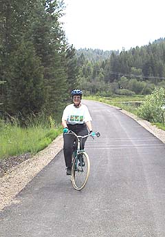
An Idahoan tries out the Trail of the Coeur d’Alenes, a recreational trail that will span the Idaho Panhandle when it is finished later this year. |
The historical enterprises of the area had its roots in farming, timbering and mining. The area now includes a wide range of tourist-related services in the towns of Wallace, Kellogg and Plummer. The Trail of the Coeur d’Alenes is an enormously rich asset to Idaho Panhandle residents and tourists alike.
Trail management
Management of the trail will be shared by the Coeur d’Alene Tribe, for the areas south and west of Harrison, and the state of Idaho, east of Harrison.
In an effort to develop a consistent management policy for both state and tribal portions of the trail, the governments collaborated on a joint management plan. This plan outlines how the tribe and state will operate and maintain the trail. The intent of this plan is to provide users with a seamless set of core rules governing trail use between the two sections of trail.
For more information, contact Jack Gunderman, Coeur d’Alene Tribe, at (208) 667-4119; or Bill Scudder, state of Idaho, at (208) 682-3814.
Phillip Cernera is the restoration coordinator for the Coeur d’Alene Tribe with 20 years of experience in mine restoration projects. Jack Gunderman is an environmental scientist for the Coeur d’Alene Tribe with 15 years of experience on large-scale environmental restoration projects Callie Ridolfi is president of Ridolfi Engineers and consultant to the tribe. The authors were instrumental in development of the Trail of the Coeur d’Alenes cleanup and construction settlement.
Other Stories:
- Water storage goes underground
- No more fuming at chemistry class
- Getting back to basics with LEED
- Seattle LEEDs the nation in sustainable building
- New stormwater rules looming for contractors
- An incubator for cutting-edge power projects
- Linking up with the environment
- Designers find new life for old cardboard tubes
- EPA turns up the heat with temperature rules
- AGC teams with WSDOT for environment’s sake
- A wholistic look at engineering
- Toxic black mold — the next asbestos?
- Mold: Getting a grip on the fuzzy stuff
- A battery of energy information
- Managing stormwater in Pierce County
- New brownfields law comes with big changes
- ‘Green infrastructure’ puts Seattle on the map
- Detention ponds – all it takes is a little magic
- Ground zero for groundwater
- A pearl of a project on Oyster Creek
- BetterBricks program stacks up energy savings
- Shopping ‘green’
- Home Depot builds atop an old Oregon landfill
- Making clean water the green way
- Salmon in the city: Seattle restores fish habitat
- A funny thing happened on the way to the dump
- Reducing energy costs, post crisis
- Does best available science work for all buffers?
Copyright ©2009 Seattle Daily Journal and DJC.COM.
Comments? Questions? Contact us.