
Surveys
DJC.COM
July 25, 2002
Does best available science work for all buffers?
Pentec Environmental
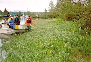
Photo courtesy of Pentec Environmental Biologists assess riparian conditions along the lower Snohomish River.
|
Washington’s Growth Management Act (GMA) of 1990 mandated that local governments establish regulations for protecting environmentally sensitive or critical areas, including wetlands, critical aquifer recharge areas, frequently flooded areas, geologically hazardous areas, and fish and wildlife conservation areas.
GMA also requires local governments to periodically update these regulations incorporating best available science (BAS) to ensure protection of sensitive areas.
What is BAS?
BAS is defined by the Office of Community Development in the Washington Administrative Code 365-195-900 et seq. According to these regulations, demonstration that BAS has been integrated in the development of critical areas policies and regulations includes:
- Identification of specific policies and development regulations adopted to protect the functions and values of critical areas
- Identification of the sources of scientific information, such as papers from peer-reviewed publications, and identification of the methods used to obtain this information
- Statements that conclusions and inferences used to establish regulations are reasonable, taken in context, and supported by underlying assumptions
Several disparities exist between lowland urban streams within developed areas around Puget Sound and the forested, larger streams where most BAS studies have been conducted.
- Inclusion of citations used in support of establishing regulations that are from credible sources and well referenced
- Identification of nonscientific information, including legal, social, cultural, economic and political information, especially any used as a basis for departing from recommendations derived from scientific data
The urban dilemma
The state Department of Ecology has recently compiled the literature comprising BAS for protecting habitats and sensitive areas in Washington.
Although Ecology has adequately identified the state of scientific knowledge of existing buffer functions — such as sediment, bacteria and nutrient removal; shoreline stabilization; temperature moderation; large woody debris recruitment; and wildlife habitat — scientists are continually learning more about various ecosystem functions and processes and how they work in urban areas.
Consequently, it is difficult to apply BAS determined for various buffer functions in undeveloped upper portions of watersheds to more urbanized reaches lower in the watershed.
The substantial widths of Ecology’s recommended buffers for various stream (riparian buffer) and wetland types are at odds with another mandate and the central purpose of the GMA — to concentrate growth in and around already urbanized areas.
Provision of 250-foot or even 50-foot buffers along many urban streams would require substantial alteration of existing land uses and removal of large pieces of the urban landscape from potential development. This would reduce the potential for increasing population density within designated urban growth boundaries. Where those streams support, or formerly supported anadromous fish, these tradeoffs may be appropriate; in other areas, they may be overkill.
The BAS literature indicates that the size of the buffer required to provide the highest level of function varies depending on the function. For example, a buffer of more than 700 feet is required to provide 90 percent of full pollutant and sediment removal, while a buffer of less than 100 feet provides 90 percent of the full potential for large woody debris recruitment.
Ecology’s recommended riparian buffer width of 250 feet for Type 1 streams is already a compromise that would provide roughly 80 percent of optimum effectiveness for sediment and pollutant removal, while a buffer of 100 feet would be 70 percent effective.
Certain buffer functions may also not be essential or even desirable in urban areas along Puget Sound. For example, a buffer of more than 300 feet is required to provide good general wildlife habitat, including large mammal migration corridors. Many of these large mammals (e.g., black bear, coyote) are not considered desirable in urban residential neighborhoods.
Also, it must be recognized that much of the scientific literature on buffer functions, especially for streams, has been obtained from large streams in undeveloped (forested) watersheds. Much less information is available on the functions of buffers in smaller and more urbanized watersheds or along large, often tidal, rivers and estuaries.
A closer look
To be most effective, shoreline master programs, surface water management regulations, sensitive areas regulations, and relevant portions of zoning codes should consistently reflect and incorporate BAS.
In practice, protection of sensitive areas has generally boiled down to establishment of vegetated buffers between natural resources — such as shorelines, streams and wetlands — with strict regulation of development within those buffers. However, it is important to note that regulations related to buffers are only one mechanism for protecting sensitive areas in the urban environment. Other local regulations that are often complementary to buffers and that help protect environmentally sensitive or critical areas include shoreline master programs, surface water management regulations, and clearing and grading regulations.
For example, one of the critical functions of riparian buffers is to moderate stormwater flows and sediment and contaminant loadings entering critical areas. An effective stormwater management program and routine maintenance activities such as removing sediments from catch basins and maintaining oil/water separators can provide much of this function in urban areas.
Disparities in BAS research
Several disparities exist between lowland urban streams within developed areas around Puget Sound and the forested, larger streams where most BAS studies have been conducted.
First, not all urban habitats can be realistically expected to provide all of the same functions or the same level of functions as those provided by similar sized streams, wetlands, or shorelines in more pristine or undeveloped watersheds.
When a stream is only 5 or 10 feet wide, a 100-foot mature riparian forest is not required to provide 100 percent of the potential buffer function for insect and leaf litter fall or moderation of temperature. Moreover, trees don’t have to be 2 feet or more in diameter to provide large woody debris (logs, rootwads) that can shape habitat and provide cover for fish in these smaller streams.
| Putting BAS to work in urban environments |
Scientists at Pentec Environmental recommend a four-step process for incorporating best available science (BAS) into protection of streams, wetlands and shorelines in urban or urbanizing environments:
|
A second disparity revolves around the fact that small streams and wetlands in urban watersheds often provide lower levels of functions, or different functions, that can be protected by smaller buffers. For example, a small stream (e.g., a Type 3 stream, with perennial flow but no salmonid use) that flows directly into an estuarine river or into Puget Sound, need not be held to the same standards (e.g., for sediment load or temperature) as a similar stream that is tributary to a larger salmon spawning stream.
Another disparity relates to the role of riparian buffers in protecting large, tidal rivers and Puget Sound shorelines such as those associated with Puget Sound’s larger urban areas.
Few studies have addressed the role of riparian vegetation in modifying ecological functions and productivity in those areas. Clearly, there is a gradual transition in the ecological roles of riparian zones from the upper watershed streams, where most research has been done, to their roles in large tidal rivers, estuaries and marine shorelines.
For example, shading by riparian vegetation is insignificant in moderating water temperature in larger tidal rivers or nearshore areas. However, where riparian vegetation overhangs a beach, the microclimate above the beach is likely to be cooler and more humid than adjacent areas lacking shade. This may allow intertidal invertebrates to extend their elevation range upward somewhat but otherwise would have little effect on habitat quality for juvenile salmonids. Shading of upper marine beaches supporting forage fish spawning is important in extending the spawning period and in increasing survival of spawned eggs.
The role of large woody debris in estuaries and nearshore areas has likewise received little study but can be reasoned to be far less important than it is in streams.
Finally, in Puget Sound’s more urbanized watersheds (most of the sound), it is not possible or practical to provide optimal performance of each function, such as sediment removal or wildlife habitat, that may require more than 300-foot buffers to achieve full functions based on the BAS.
A goal of local ordinances should be to use the tools of regulation to require that reasonable, improved or enhanced buffers be added to development or redevelopment sites as a permitting condition. This approach can lead to a long-term improvement in the functions of critical habitats in urban areas while allowing reasonable development.
By understanding the derivation of BAS and its relevance to urban areas, local governments can successfully advocate (and receive Ecology approval of) buffers and development standards that protect existing functions within their jurisdictions while balancing other goals of GMA, such as focusing growth within urban growth boundaries where infrastructure already exists.
Working BAS into the urban environment
Although state-mandated deadlines have recently been relaxed, municipalities and counties in Puget Sound are required in the near future to update their critical or sensitive areas ordinances and shoreline master programs to reflect BAS.
Scientists at Pentec have assisted several municipalities with writing and updating their critical areas ordinances and shoreline master programs, including the cities of Auburn, Bothell and Everett. They have successfully advocated buffers and development standards that protect existing functions while balancing other goals of GMA, such as focusing growth within urban growth boundaries where infrastructure already exists.
In addition, using an innovative salmon habitat inventory model, Pentec has been able to identify and prioritize habitat restoration opportunities at a watershed scale that have a strong likelihood of effectively contributing to recovery of salmonid species listed as threatened or endangered under the Endangered Species Act.
Scott Luchessa is a senior wetland ecologist at Pentec with more than 16 years of experience in terrestrial and aquatic ecology. Jon Houghton, Ph.D., has more than 33 years of experience in freshwater, marine and estuarine biology.
Other Stories:
- Water storage goes underground
- No more fuming at chemistry class
- Getting back to basics with LEED
- Seattle LEEDs the nation in sustainable building
- New stormwater rules looming for contractors
- An incubator for cutting-edge power projects
- Linking up with the environment
- Designers find new life for old cardboard tubes
- EPA turns up the heat with temperature rules
- AGC teams with WSDOT for environment’s sake
- A wholistic look at engineering
- Toxic black mold — the next asbestos?
- Mold: Getting a grip on the fuzzy stuff
- A battery of energy information
- Managing stormwater in Pierce County
- New brownfields law comes with big changes
- ‘Green infrastructure’ puts Seattle on the map
- Detention ponds – all it takes is a little magic
- Ground zero for groundwater
- A pearl of a project on Oyster Creek
- BetterBricks program stacks up energy savings
- Shopping ‘green’
- Home Depot builds atop an old Oregon landfill
- Making clean water the green way
- Salmon in the city: Seattle restores fish habitat
- A funny thing happened on the way to the dump
- Reducing energy costs, post crisis
- A trail of mining waste turns into a trail of recreation
Copyright ©2009 Seattle Daily Journal and DJC.COM.
Comments? Questions? Contact us.