
Surveys
DJC.COM
June 28, 2007
Developers must dodge newly discovered fault hazards
Aspect Consulting
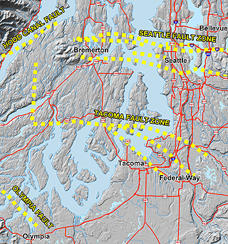
Image courtesy of Aspect Consulting
Recently identified fault rupture hazard zones cross densely populated areas of the Puget Lowland. Scientists say there is a good chance of one or more of these faults rupturing within our lifetimes. [enlarge]
|
![[enlarge]](/stories/images/20070628/Faulthazards_AreaFaults_big.jpg)
If you live, work, or commute through downtown Seattle, Tacoma, Olympia, Bellevue, Bremerton or Issaquah, chances are you travel across or spend your day close to one of many recently discovered active fault zones. Within the past 15 years, scientists have identified at least six active fault systems in the Puget Sound area, four crossing major urban areas.
Locations of the multiple fault strands within the Puget Lowland’s six active fault zones are generally unknown. While many faults will remain hidden beneath our developed urban areas, many will be mapped in the coming decade and more shown to be active. Since active faults are considered to have future potential to rupture and trigger large earthquakes, knowing the locations of these faults will change the way development proceeds.
Nature of the hazard
Every 15 to 20 years, we are reminded of earthquake risks in our region by the moderate earthquakes that topple chimneys, shake bricks loose from historic buildings, and temporarily close bridges and airports. Earthquakes most of us have experienced — including the 1949 Olympia earthquake, the 1965 Seattle-Tacoma earthquake or the 2001 Nisqually earthquake — were generated deep in the earth. We were protected by the great depth of their source. Today, scientists are finding shallower earthquake sources with the potential to cause severe damage and loss within our lifetimes.
The faults that most worry geologists, planners and emergency responders are shallow crustal faults. Earthquakes generated by these faults may equal the intensity and damage from the largest California earthquakes experienced in the last century, including the 1906 San Francisco earthquake, the 1989 Loma Prieta earthquake and the 1994 Northridge earthquake. But finding evidence of these faults is not easy.
High-resolution topographic ground surface mapping using an airborne laser rangefinder that can penetrate dense vegetation now helps geologists locate traces of past ruptures from shallow faults. Much of the Puget Lowland has been flown to collect this information. Images are being analyzed as rapidly as they are being developed. Each year several of these traces are trenched to determine if they are active faults. Agencies responsible for mapping and assessing the hazards are continually adding to the list of known hazards.
Based on results from these initial studies, scientists and emergency planners at the Seattle Fault Earthquake Scenario Conference in February 2005 revealed a credible scenario of a future magnitude 6.7 earthquake and rupture of the Seattle fault. Because of the earthquake’s shallow nature, and its location in a highly developed area, the scenario predicted loss of thousands of lives and tens of billions of dollars, including the destruction of nearly 10,000 buildings. This type of credible information will lead regional planners and lawmakers to take steps to evaluate and reduce the hazards.
The impact on development
As hazards are refined and more fault strands located, development stands to be significantly impacted. Municipalities and planners can address increasing seismic hazards by zoning regulations to restrict building in high-risk areas, and establishing building code standards for new construction in areas where mitigation is reasonable.
For planning and design purposes, earthquake hazards on these faults are generally divided into two types: ground rupture, which occurs where movement on a fault plane extends upward and causes a break or fold at the ground surface; and ground shaking, which is the back and forth motion that occurs during earthquakes.
The nature of these two hazard types — and how they will be addressed by regulators — is quite different with regard to proximity to the faults. The intensity of ground shaking diminishes gradually with distance from a fault, so knowing the exact location of each fault strand is not important when addressing ground motion hazards. On the other hand, surficial rupture hazards are limited to areas where faults propagate to the surface. In order to avoid these areas, it is critical to know the exact locations of the faults.
Ground shaking is generally considered in building codes and in the design of structures that involve life safety. Most Western Washington municipalities have adopted design requirements based on the International Building Code. Ground shaking maps are being revised to incorporate newly discovered faults and the high-risk areas will expand significantly.
Surficial rupture can be very damaging to structures that straddle the rupture zone if they are not specifically designed to accommodate the movement. In municipal codes, surficial rupture hazards are usually dealt with by setbacks. Since rupture zones are typically long and narrow, large setbacks are generally not necessary.
The chief difficulty lies in identifying faults in dense urban areas where development has covered evidence of faults, and in realistically assessing the level of risk that they present. Assessing the risk is difficult because of the recency of our postglacial landscape and the small number of locations that have been studied.
Consequences
Structures sited within areas of intense ground shaking from newly identified fault zones will be built to significantly higher standards than under the old codes. Combine this with expanding zones of high-hazard areas, and regional construction costs will rise.
Development of major structures may also require a PSHA, or probabilistic seismic hazards analysis. PSHA studies are used to determine the probability of an earthquake, the probable magnitude of the ground motion, and the probability of ground rupture occurring at a specific site. In many areas, a PSHA study could result in design requirements more stringent than the International Building Code-based allowance.
Increased ground shaking hazard poses additional consequences for steep sites in landslide-prone areas. Some sites considered stable under existing building codes and seismic shaking design level will be considered unstable based on newer information and codes. While this will not preclude development of all hillside sites, it will require developers to address the higher risk, resulting in more time and money spent on studies to assess slope stability and more complicated permit requirements. It may also result in expensive engineering design and construction or measures to stabilize slopes.
Rupture hazard implications
There have been no earthquakes on crustal faults in populated areas of Washington state in historic times. Consequently, regional standards-of-practice do not exist, most municipalities have not established regulatory requirements for investigating surficial rupture hazards and assessing risks, and there are no required building setbacks or construction mitigation. This could change if state or local municipalities follow the lead of several other western states. California and Utah have adopted requirements of 15- to 50-foot setbacks from active faults for all structures intended for occupancy. Nevada has adopted recommendations for conducting fault hazard investigations.
The difficulty in adopting similar blanket setback rules in Washington lies with a number of factors complicating the assessment of risk of future fault ruptures. First is that our fault systems are geometrically different from those in other western states. Second, the history of fault movement here is not as well understood as in many California faults where records of past movement are well documented. A third complicating factor is the suggestion that many of our faults do not appear to rupture with the regularity of California faults.
In the absence of quantitative risk data, geologists have recommended precautionary setbacks — typically about 50 feet — for incorporation into municipal code in Western Washington. Yet some municipalities have no requirements, while some require only that permit applicants be notified of potential rupture hazards and offer suggested setbacks from identified active faults. Continued discussions will likely lead to change.
Early last month, a group of geologists, engineers and land-use attorneys involved in studies of faults met to discuss the issue of regulation of development in areas of fault rupture hazards. Both the Association of Environmental & Engineering Geologists and the American Society of Civil Engineers are developing recommendations on whether the state Legislature should wait until the hazards are better defined, or act now to promote geologic studies in areas of identified rupture hazard, and possibly adopt restrictions on development over these features.
The state of knowledge of the hazards associated with active faults is in its infancy. Site developers should expect continued findings of our region’s seismicity to result in restrictions in land use around identified high-hazard areas, new requirements for site-specific studies, and increased time and costs to address these new hazards.
Dave McCormack is an associate engineering geologist with Aspect Consulting, which focuses on engineering geology, geotechnical engineering, water resources and environmental consulting. McCormack specializes in geologic hazards and stratigraphic analysis.
Other Stories:
- Cleaning up stormwater runoff on freeways
- New Seattle hotel to marry luxury with green
- Lakehaven solves water woes with ASR
- Treating rural wastewater is a daunting task
- The Emerald City’s tourist industry turns green
- Are nanomaterials another environmental worry?
- Tribe’s waste plant doesn’t raise a big stink
- When BMPs can’t meet stormwater permit rules
- Contaminated site? Let Mother Nature help
- Why integrated design is off to a slow start
- Study your options when banking or reserving wetlands
- A solution to our dwindling water supply lies below
- What to know when buying a contaminated site
- Blending a new community into the environment
Copyright ©2009 Seattle Daily Journal and DJC.COM.
Comments? Questions? Contact us.