
Surveys
DJC.COM
June 28, 2007
Lakehaven solves water woes with ASR
Robinson, Noble & Saltbush

Becker
|
Water is problematic in Washington. In summer, when supplies are low, there is a large water demand for municipal, irrigation, recreational and in-stream uses. In winter, when cultural and agricultural demands are low, there is an overabundance of water.
One solution to this imbalance is the use of aquifer storage and recovery (ASR) techniques to preserve winter surplus water in underground aquifers for summertime municipal use. Lakehaven Utility District in Federal Way is embarking on such a program to store enough water to annually serve the summertime needs of more than 100,000 people, including some within other utility districts.
Conceived in the early 1990s, Lakehaven’s ASR operation, termed the OASIS Project, is now being built after receiving the necessary state permit last fall. OASIS stands for “optimization of aquifer storage for increased supply.”
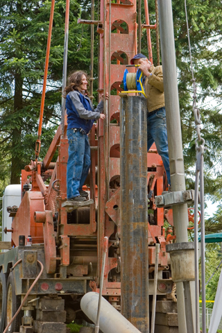
Images courtesy of Robinson, Noble & Saltbush Hydrogeologist Collette Foley and driller Jim Niederkorn measure a water level during the drilling of Lakehaven Well 34M. |
Last September, Lakehaven received a water right reservoir permit from the state Department of Ecology to begin building the project. Upon full build out, the permit will allow Lakehaven to artificially recharge and store 29,000 acre-feet of water (approximately 9.5 billion gallons) underground every winter for recovery via numerous wells during the summer at collective rates up to 54,000 gallons per minute.
The permit allows the project to commence in two pilot phases followed by four operational phases. Major work on the first phase is beginning this year with the drilling of the first dedicated ASR well.
The district’s hydrogeologic consultant, Robinson, Noble & Saltbush, is designing the well to be capable of injecting or pumping water at rates up to 3,000 gallons per minute. Drilling will begin before the end of summer. Ultimately, the project is anticipated to include 27 wells.
Federal Way aquifers
Several aquifers exist on the Federal Way Upland. The project will take advantage of the Mirror Lake Aquifer, so named because it is approximately centered under Mirror Lake at a depth of 300 to 500 feet (but not hydraulically connected to the lake).
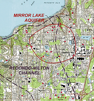
The Mirror Lake and Redondo-Milton Channel aquifers are two of the major aquifers in the Federal Way area. The OASIS Project is using the Mirror Lake Aquifer as an underground reservoir. |
The Mirror Lake Aquifer is the second major aquifer downward from the surface of the upland. It occurs underneath the Redondo-Milton Channel Aquifer, which not only serves as a major well production source for Lakehaven but also provides the majority of base flow to area streams. The water to be stored and recovered in the first OASIS phase will come from Lakehaven’s wells completed in the Redondo-Milton Channel Aquifer. The second phase will use excess surface water from the Green River.
Water levels in the Mirror Lake Aquifer have been depressed from their natural levels since the late 1980s, by up to 70 feet, due to well production. It was this decline in water levels, and the increased storage capacity implied by the decline, that first led to the idea of using the aquifer for large-scale ASR operations.
Under full operation, the OASIS Project will raise the water level in the Mirror Lake Aquifer back to its highest observed natural level, approximately 200 feet above sea level. During the summer months, when the stored water will be recovered, water levels in the aquifer will be drawn down to near sea level.
Ecology is concerned that the annual raising and lowering of the water level by 200 feet may have unintended consequences. Therefore, the permit requires Lakehaven to monitor for environmental changes and provide mitigation if necessary.
A large portion of the first phase of the project involves setting up monitor networks. For example, to address the possibility that the annual raising and lowering of water levels may cause deformation of the land surface, this spring Lakehaven established an elevation network of surveyed benchmarks throughout the northern Federal Way Upland. This network will be re-surveyed on a regular basis to identify any such changes.
Stream monitoring
By monitoring both area streams and aquifer water levels, Lakehaven is also looking into whether the large annual declines in water levels will cause additional groundwater leakage out of the Redondo-Milton Channel Aquifer to the Mirror Lake Aquifer, which could lead to declining stream flows. In this regard, our hydrogeologists are working with United States Geological Survey hydrologists to re-establish formerly active stream gages on Hylebos, Lakota and Cold creeks. Efforts are also being made to establish a well monitoring network dedicated to looking at vertical water movement, also known as leakage, between the aquifers.
Last year, Lakehaven installed Well 34M as the first well in this network. Well 34M is triple piezometer, meaning that it consists of three separate lengths of pipe each open at discrete depths, which will monitor water pressures in the Redondo-Milton Channel Aquifer, the Mirror Lake Aquifer and the clay layer between the aquifers. This well, and two other similar wells to be drilled next year, will allow us to examine how the leakage between the two aquifers differs during the recharge, storage and recovery phases of OASIS operations.
Groundwater monitoring
The area north of the Mirror Lake Aquifer overlooks Poverty Bay on the shore of the Federal Way Upland. This area has become substantially more developed since aquifer water levels were at their naturally high level. Lakehaven is monitoring groundwater-related changes along this bluff to examine how the return of high aquifer water levels may affect the slope above Puget Sound. This monitoring is occurring as a biannual survey of groundwater seepage and spring flow.
The baseline survey locating areas of seepage and previously unmapped springs occurred in May. The second survey of the year will be conducted in the fall. To further examine this issue, another monitoring network is being established by Lakehaven to examine trends in shallow groundwater levels. This network will consist of several sets of shallow wells to be installed later this year at key locations near major groundwater discharge points and upland lakes.
Years in the making
The original feasibility study for OASIS occurred in 1994. For several years the OASIS Project was not pursued due to a lack of clear law regarding the ownership of artificially recharged water. In 2000, the state Legislature clarified the issue by expanding the definition of a reservoir to include aquifers, largely as a direct response to the OASIS Project. Later that year, Lakehaven submitted a reservoir application for the project.
It took an additional three years, as a result of a rule-making process, for Ecology to begin processing the application. Ecology provided the district with a draft report of examination for the application in September 2005. Following negotiations with the district and tribal interests, an amended draft report of examination was written in May 2006.
A final approved reservoir permit for the project was received by the district in September 2006, more than a decade after the project was deemed feasible and a full six years after the application was submitted.
The district received a final approved reservoir permit in September 2006, more than a decade after the project was deemed feasible and a full six years after the application was submitted.
Joe Becker is a hydrogeologist who specializes in water-resource development and protection. He is president of Robinson, Noble & Saltbush in Tacoma.
Other Stories:
- Cleaning up stormwater runoff on freeways
- New Seattle hotel to marry luxury with green
- Treating rural wastewater is a daunting task
- The Emerald City’s tourist industry turns green
- Are nanomaterials another environmental worry?
- Tribe’s waste plant doesn’t raise a big stink
- When BMPs can’t meet stormwater permit rules
- Contaminated site? Let Mother Nature help
- Why integrated design is off to a slow start
- Study your options when banking or reserving wetlands
- Developers must dodge newly discovered fault hazards
- A solution to our dwindling water supply lies below
- What to know when buying a contaminated site
- Blending a new community into the environment
Copyright ©2009 Seattle Daily Journal and DJC.COM.
Comments? Questions? Contact us.