|
Subscribe / Renew |
|
|
Contact Us |
|
| ► Subscribe to our Free Weekly Newsletter | |
Construction Bids
| home | Welcome, sign in or click here to subscribe. | login |
|
|
Whodunnit, and when?
Forensic history and archaeology in redevelopmentBy ROBERT M. WEAVERHart Crowser, Inc. There are far too many harrowing tales about site development problems created in response to concerns over archaeological resources. Recent examples include work stoppage at the Seattle World Trade Center when human remains were unearthed during construction. Even more recently, the potential legal action against contractors over excavation of burials near Semi-ah-moo near Blaine point to the need for incorporating archaeological planning into development projects. In most cases, serious problems can be avoided with advance planning by qualified personnel. At Hart Crowser, however, we have been using archaeological techniques to serve a new purpose. Using the experience in historical research and investigations, we have developed a system that incorporates archaeological observation to improve our hazardous waste and redevelopment engineering services. The purpose is to enhance and reduce costs in hazardous waste site investigation; and to find out precisely when contaminants were re-leased, identify responsible parties and facilitate cost sharing for cleanup.
The historic dimensionAlong with a greater number of participants in each project, beginning with regulatory agencies, municipalities, developers and environmental contractors, there is more need for refined solutions in identifying and involving responsible parties. Historical research and forensic application of archaeological techniques adds dimension to standard industry practices.
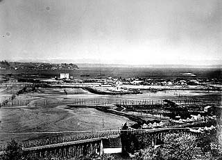
Environmental investigations today should begin with a model of anticipated conditions. The information needed includes what businesses operated on the property, what and where were operations that could cause contamination and what changes in technology for a particular industry reflect changes in contamination potential. Few people realize that at the turn of the century, a milk processing plant would have manufactured their own lead solder-sealed cans, which could result in a heavy metals problem. The conceptual model generally integrates historical use, geological structure, and local hydrology to predict the locations of contamination. But in many cases, the model goes further. Particularly in reclaimed and redeveloped land, site investigation requires an archaeological approach to understand where the contamination lies. Likewise, locating sampling points with the greatest potential for hitting wastes depends on almost an anthropological understanding of human behavior. Look on old maps for the doors to buildings and old fence lines for that daily bucket of paint and solvent that an employee had to "get rid of." Manufacturing and commerce in the 1800s built their facilities on wharves over the former Seattle tideflats. Trap doors and pipes swept the daily wastes down onto the surface of the flats. Then came the great fire of 1889, when the debris accumulating from redevelopment went into the tide flats. As the city grew, developed, expanded and recontoured through projects like the Denny and Jackson Street regrades, additional layers were added to the fill zones. Finally, today's plants and businesses built their facilities on the fill. Not only does this layer cake have great range of materials and strange contaminant migration patterns, it also has zones of contamination that are discreet to individual layers. Standard environmental sampling practices often result in cross sampling zones - even inadvertent cross-contamination of layers. With complex sites, this tends to misdiagnose problems. By understanding discreet stratigraphy, it is possible also to date contamination and link that to the then operator of the site. This takes a combination of information that is more historical and archaeological than knowing the layers of deposited fill. For example, certain types of fuel or lubricants or additives may only have been used for a particular time period. Corporate records combined with special testing technology can isolate those additives and identify the responsible party. On waterfront sites, researching Corps of Engineers and corporate records on waterway dredging can provide a sequence of filling and dredging. Aerial and surface photographs show site activities and locations, and careful sampling and analysis of contaminants help develop associations. In particular, datable artifacts provide key evidence on when layers were deposited. In the lead contamination example discussed above, part of the clues to interpretation rested in all of the "neat old historic bottles" that came out of the investigation. By dating the bottles based on type, construction, and producer, the design consultant was able to date the layer.
Start at the beginningCollecting and using evidence on contamination has to be integrated into site investigations from the very start. Why? Remediation and redevelopment of sites can be very costly. Both state and federal laws allow for cost recovery from responsible parties. But the relationship between a contaminated site and a potentially responsible party must be proved. As the process has become more sophisticated, the level of proof has become even more demanding. We aren't talking about yesterday's companies. In the northwest, contamination can be over 150 years old. Historical documents such as title records, corporate registrations, Sanborn fire insurance maps, probate records, city directories and more help to develop the history of companies associated with sites. These records lay the foundation for a claim and the sampling and analyses provide the technical basis. But careless sampling can forever cast doubt on the results and greatly reduce the opportunities for recovery. Traditionally, companies must file suit to obtain cost recovery. Many companies, however, have started to realize that the cost of a court battle may exceed the cost of cooperation. Convincing evidence developed through research and site investigation often can push results beyond contentious opposition to negotiated settlement or joint cooperation. Sometimes forensic archaeology can help even after a remedial action. In a recent project, a client and former contractor developed a remediation plan for a property. During excavation, they encountered more and more contamination, which resulted in doubling the excavation. The focus was on getting rid of the contamination. Verification sampling documentation was limited, field notes and reports were almost non-existant and the "evidence" was hauled away. By conducting focused historical research and by documenting the micro-stratigraphy and artifacts in remaining sidewalls, we have been able to "reconstruct" the history of filling, site use, and associated parties to a degree that allows the client to pursue cost recovery. It is, however, better to anticipate needs and collect evidence before turning a blade of earth. By taking the necessary steps to fully understand the site conditions and constraints, and plan for site investigation, an owner or developer significantly enhances the chances for a successful redevelopment project.
Robert M. Weaver is principal research historian with Hart Crowser. He has 24 years of experience in cultural resources and environmental studies throughout the United States, and he has served six years on the Seattle Landmarks Commission.
 djc home | top | special issues index
|