|
Subscribe / Renew |
|
|
Contact Us |
|
| ► Subscribe to our Free Weekly Newsletter | |
Construction Bids
| home | Welcome, sign in or click here to subscribe. | login |
 April 20, 2000 A step at a time through Seattle�s downtown wayfinding project A multi-disciplinary design team and a coalition of clients find that it�s not easy out there for an out-of-towner on foot
By PAULA REES A city is personified by its "language of the street." The messages, the visual images, the symbols-even the sounds and smells of the street-become part of a town�s lasting impression on the memories of visitors from near and far. In historical cities, the clues that help us become comfortable are often very integral to the place, because it was created for pedestrians and not the automobile. But an American city like Seattle must create its own positive and civil language of the street. This language makes the city comprehensible to the individual person and the pedestrian through purposeful design and an attention to detail. Under the leadership of a design-savvy Mayor, the sponsorship of the Downtown Seattle Association and the focused energy of Seattle�s twelve distinctive downtown neighborhoods it became clear that Seattle could benefit from a comprehensive "wayfinding" plan. Wayfinding involves the design of "directional" communications, which might include directories, maps or pictograms that guide people to destinations. Environmental design involves the planning, design and specification of communication elements, most often in the built-environment. Practitioners typically come from related fields such as graphic design, landscape architecture, architecture, industrial design, interior and exhibition design. For Seattle�s growing needs, a collaborative of environmental designers and a landscape architecture firm were hired to guide over 50 stakeholder groups through the task of defining the key zones, destinations and elements of a wayfinding program. These stakeholders have included: the city offices of the Mayor and Strategic Planning, the Downtown Seattle Association, the Convention Center, transportation authorities, art and design commissions, various neighborhood representatives, the Chamber of Commerce, the City Council, the Port of Seattle, the Visitor�s Bureau, historic districts, the Stadium Authority and public facilities like Seattle Center and the Aquarium. The design team includes Maestri, Nakano Associates, Jon Bentz Design (all in Seattle) with Two Twelve Associates (NY).
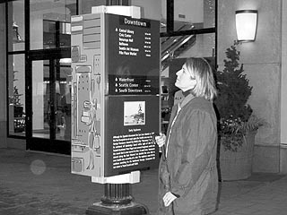
The research uncovered several issues. The most frequently asked questions in the retail core: Where is Pike Place Market? Where is Space Needle? Where is Pioneer Square? A local resident may see these as self-evident, but from the frequency of the questions, it�s clear that for the visitor finding one�s way is difficult. To understand the larger picture the team first presented successful wayfinding examples from cities around the world. Then, in comparison, the specifics of what has been done in Seattle over the years was photographically catalogued. Sure enough, "parking" signs crowd the public-right-of-way, consuming the limited pedestrian streetscape. The regulation of vehicles leaves little room for people. Ironically, our city is full of signs and objects spaced at the pedestrians pace of walking-yet intended solely for the cars flashing (or these days crawling) by. And it wouldn�t surprise visitors to Seattle to hear that conditions are not good. Ill repair, graffiti, unreadable messages, crooked mounting, signs not even facing the intended road, countless placement heights, no evident hierarchy, and messages randomly stacked like totem pole characters are some of the catalogued conditions. The project team determined that more messages could be added for the benefit of pedestrians and transit users. But it would require high quality design standards including integrated design, thoughtful typography, organized color systems, consistent mounting heights and fewer postings. In addition, to be truly successful, elimination of existing redundancy and replacement with a comprehensive plan is required. Clearly, this is a case where fewer are better. On review of the stakeholders requests and our report, Mayor Paul Schell asked that all old and unnecessary signs be removed-a major improvement for any city. When completed by SEATRAN, this measure will be an important first step. But Seattle has yet to decide just how "civil" it wants to be. Ninety nine percent of Seattle�s signs are strictly vehicular and regulatory-as in "no parking," "no stopping," or "one way." While a few signs were meant for pedestrians, the messages were negative and prohibitive. If a retail store communicated in this way to its customer, there wouldn�t be many shoppers left. The "language of the street" is our opportunity to communicate who we are and whom we aspire to be. It is our opinion that adding more messages to our streetscape without considering the need to refine the existing context will only make the problem worse, adding more visual chaos and confusion. With this in mind we generated a series of recommendations around integrated elements at different scales to organize, limit, clarify and present the words and symbols which help all of us find our way and feel at home whether a visitor or resident, in a car or walking. Elements of different scales will serve different purposes. The use of International Symbols were advanced in the 1960�s and 70�s through transportation issues around multi-lingual locations such as airports, transit hubs, and national parks-and in "event" locations. Providing clear locations and directions for information centers, money exchange, public restrooms, and transit access are a few of the things that will make Seattle a more civilized place. A demonstration project of the Seattle Wayfinding Program, called "pedestrian directionals" can be experienced on Pike and Pine Streets and First Avenue. This is intended to show just one element of the plan and the potential of a comprehensive and integrated design. When you check it out, imagine all of Seattle�s messages having similar quality and clarity of purpose. With all its cultural facilities and unique destinations, Seattle is more than ready for a world-class wayfinding system. This is just the beginning. Seattle�s "language of the street" will unfold a step at a time.
Paula Rees is founder of Maestri and a past president of the Society for Environmental Graphic Design.
|