|
Subscribe / Renew |
|
|
Contact Us |
|
| ► Subscribe to our Free Weekly Newsletter | |
Construction Bids
| home | Welcome, sign in or click here to subscribe. | login |


| |
January 16, 2001
Last December, the Lower Duwamish Waterway of Seattle was proposed for Superfund listing in order to address the threats from hazardous substances to the human food chain and to sensitive environments of the river.
|
Sediments in the lower Duwamish River are contaminated with PCBs, inorganics and other toxics. The lower Duwamish River serves as a migratory route, nursery and as habitat for several species of Pacific salmon. Salmon use the lower Duwamish River during a critical stage of their migration from a fresh water to a salt water environment, and bald eagles use the area for nesting.
How might such habitat be restored for fish and wildlife?
Commencement Bay Nearshore/Tideflats (CB/NT) consists of 10-12 square miles of shallow water, shoreline and adjacent land, most of which is developed and industrialized.
A century of industrial activity, including dredging and filling, combined with releases of toxic chemicals severely impacted the local environment. Marine sediments are contaminated from diverse industrial activities including shipbuilding, oil refining, chemical manufacturing and storage, and pulp and paper mills, dating from the turn of the century.
Commencement Bay was added to the National Priorities List (NPL), or Superfund, in September 1983. EPA's 1989 Record of Decision (ROD) set forth a cleanup plan that included control of upland sources, followed by sediment remediation by dredging and containment or capping, for eight contaminated sediment problem areas: the St. Paul, Sitcum, Hylebos, Thea Foss, Wheeler Osgood, and Middle waterways.
|
CB/NT was the first site in the nation to complete a partial delisting of clean areas from the NPL.
State and federal agencies and the private sector have undertaken source control, cleanup and habitat restoration activities in Commencement Bay. The Commencement Bay Natural Resource Trustees have developed a Bay-wide restoration plan and are designing and building a series of habitat restoration projects utilizing funds, property, and in-kind services obtained as a result of settlements of natural resource damage claims.
The sediments of the Hylebos Waterway are contaminated with PCBs, other organics and metals from several industrial operations including chemical manufacturing plants, scrap metal recycling, log transfer facilities, and shipbuilding.
EPA will begin Consent Decree negotiations in early 2001 to design and implement the sediment remedy, which includes dredging 940,000 cubic yards and capping 11 acres of contaminated sediments. EPA plans to complete the cleanup by 2003.
|
Sqaully Beach is one of two sites in Commencement Bay where restoration work was performed during the year 2000.
The work was performed on behalf of the Commencement Bay Natural Resource Damage Assessment (NRDA) and Restoration Trustees.
The Trustees include the National Oceanic and Atmospheric Administration (NOAA), the U.S. Department of the Interior (U.S. Fish and Wildlife Service), the Puyallup Tribe of Indians, the Muckleshoot Indian Tribe, the Washington State Department of Ecology (lead agency for the state), the Washington State Department of Natural Resources, and the Washington State Department of Fish and Wildlife.
Ridolfi Engineers provided the engineering design and consulting services to implement the restoration projects. This was the first engineering design project conducted by NOAA in Commencement Bay. The following tasks were conducted:
Ridolfi assembled a team of technical specialists to study the sites, evaluate the restoration opportunities, and develop designs.
Several conceptual designs for each site were developed and presented to Trustees and the public to refine the design. Ridolfi developed plans and specifications and provided technical support for construction contractor selection.
Ridolfi also provided construction phase services to verify that construction went according to plan. Construction was implemented by Remtech under a separate contract with NOAA.
The design team included Ridolfi Engineers Inc, project management and restoration planning and design; EVS Environmental Consultants, environmental characterization; Adolfson Associates, environmental compliance and permitting; Dinnel Marine Research, fisheries, marine ecology and toxicology and shellfish consulting; and Osborn Pacific Group, landscape architecture.
The engineer's initial estimate came in at $449,000. Remtech's original proposal was $443,000 with a final invoice amount of $505,000.
Sqaully Beach shows challenges of urban restoration
The Commencement Bay Trustees selected Squally Beach as a habitat restoration site because it was in a relatively unimpacted area of the heavily industrialized Tacoma tideflats. A corner of the site supporting native plants hinted at the potential for a small but thriving upper salt marsh environment.
Stormwater flowing under the site through culverts offered the possibility of mixing fresh water with salt water to increase the variety of plants that could be grown.
The Squally Beach site is located along the northern shoreline of the Hylebos Waterway, south of Marine View Drive and immediately west of East 11th Street. The project site consists of approximately 0.66 acres of uplands bordering an extensive area of intertidal mudflats immediately west of the site.
The Squally Beach site is situated adjacent to the largest area of original mudflats in Commencement Bay
Prior to restoration, the Squally Beach site contained some hardwood trees, blackberry bushes, and a strip of intertidal marsh vegetation approximately 3 to 4 feet wide growing at approximately the mean higher high water (MHHW) elevation.
The upland portion of the site was covered with blackberry bushes and other invasive plants and was used as a dump site.
Expansion of the existing salt marsh vegetation at the site was the primary goal for the project. The site contains salt marshes and low-gradient mudflats that provide habitat for bottom-dwelling organisms important to the food chain.
These organisms are of particular importance to shorebirds and juvenile salmon. The site contains several pilings, logs, and downed wood indicative of previous log storage activities in the vicinity.
The design team expanded on the goals identified by the Trustees to include habitat creation for small mammals and birds. This could be accomplished by intercepting and using fresh water from the two stormwater discharges that cross the site in a channel or channel and pool system.
Additionally, the design team wanted to create more passages from the site to the mudflats area that could convey food such as insects and detritus for use by out-migrating salmonids. This could be accomplished by establishing food source areas such as riparian zones adjacent to the channel system, which would contribute appropriate materials from overhanging branches.
The Trustees selected a branching channel alternative for the Squally Beach site. The Trustees selected this alternative based on a desire to maximize production of salt marsh vegetation.
Important considerations for this alternative are:
The design of this project is consistent with the overall objective for the Hylebos Waterway of increasing the winding nature of the creek channel and increasing the area and quality of the intertidal habitat. The design phase was completed in late 1999 and construction was completed in the fall of 2000.
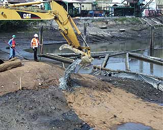
Construction work at the Squally Beach site included clearing, debris removal, excavation and grading to reach design elevations, construction of rock outlet structures, installation of toe logs and hydroseeding.
Construction of the salt marsh at the Squally Beach site consisted of excavating to the appropriate subgrade elevations and placing organic-rich topsoil to serve as a growing media.
Additionally, four tidal inlets were constructed to allow seawater to flow across the site and to provide drainage points for the diverted stormwater.
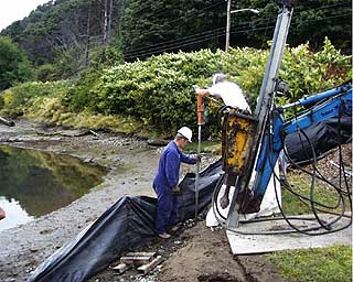
Elevated berms were graded between the tidal outlets to help control the flow of water. Toe logs were installed parallel to the shoreline at the Squally Beach site to reduce the potential for erosion in areas with cut banks.
The toe logs were 10 to 30 feet in length with diameters in the one- to two-foot range. The end of each toe log was secured with two Manta Ray brand earth anchors. Ten toe logs were installed at the site.
As with the Mowitch site, the other CB/NT restoration performed by Ridolfi, hydroseeding technology was used to place grass and forb seed in upland areas of the Squally Beach site. Following seed application, a two-inch layer of sterile straw was blown over upland areas to provide erosion control.
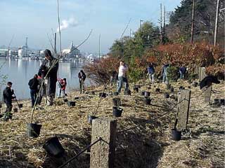
The first upland planting occurred in November 2000, when volunteers from Citizens for a Healthy Bay, Stadium High School, and Boy Scout Troop #248 assisted the Trustees with the planting of upland trees and shrubs at the Squally Beach restoration site. Further upland and intertidal vegetation planting will occur in spring 2001.
The Trustees are developing a monitoring program for the restoration sites in Commencement Bay. Measurements will include topography, nutrients, plant growth and coverage and water levels.
The information gleaned from the monitoring program will be used to try and maximize the success of future restoration efforts in the area.