|
Subscribe / Renew |
|
|
Contact Us |
|
| ► Subscribe to our Free Weekly Newsletter | |
| home | Welcome, sign in or click here to subscribe. | login |
Architecture & Engineering
| |
 |
February 29, 2024
Engineering with support from the sky
Herrera

Schreder
|

Ode-Giles
|
At its most basic application, deploying drones at a project site can capture conditions and provide site context through aerial photography and videography, showing the surroundings, documenting progress and offering visually-engaging deliverables to display conceptual and completed work. This can provide engineers and project partners with a shared understanding of site conditions, constraints and desired outcomes to develop a well-considered project approach.
Project managers and clients can use this information to better assess site conditions for improved project implementation. Our team can apply the use of drones to architectural and engineering projects through conceptual design renderings, project concept communication, construction oversight and site characterization. Drones offer an alternative approach to data collection that provides engineers with unique advantages over traditional methods.
ADVANTAGES OF PHOTOGRAMMETRY
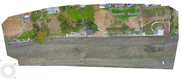
In addition to capturing aerial photographs for basic site communication, drones enable nimble and high-resolution site renderings through photogrammetry. In photogrammetry, drone pilots take many overlapping aerial photos which are then processed in specialized software to produce useful outputs, including distortion-corrected orthophotos, elevation surfaces and 3D models. These outputs can provide high utility at all phases of the project life cycle.
Distortion-corrected orthophotos are often used as high-resolution base imagery for CAD and GIS drawings, enabling the production of detailed site plans that reflect most-current site conditions. This is especially valuable in areas with only low-resolution or outdated aerial imagery from conventional service providers.
Similarly, elevation surfaces produced through photogrammetry can offer high-resolution topographic representations of a site’s current conditions, reducing surprises in the design phase and enhancing communication among remote teams. This has additional benefits in construction oversight, as elevation surfaces produced from multiple drone flights can be applied to calculate cut and fill volumes, compare design elevations to on-the-ground conditions, and clearly identify and communicate where adjustments may be needed. For greatest efficiency and accuracy, modeled elevation surveys can be tied in to established survey control on-site.
Elevation models and orthophotos can be combined to create 3D models, which facilitate cross-team collaboration and vision-sharing for clients and stakeholders and can be deployed in augmented reality and virtual reality to illustrate the current state of the site compared to proposed changes. Photogrammetry empowers engineers with the data and tools to produce compelling, cost-effective deliverables while reducing time spent on-site for project personnel.
A DRONE CASE STUDY
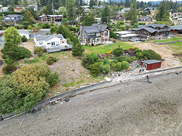
Herrera’s support of the Northwest Straits Foundation’s shore-friendly armor removal case study demonstrates how drones benefited the project and inspired further work. This study focused on the preliminary design phase of a broader program to facilitate grant-funded stewardship and restoration of privately owned coastal property in the Salish Sea. The project’s objective is to remove shoreline armor, such as concrete bulkheads and rock walls, and restore the natural shoreline. In this case study, we focused on a portion of the project that initially involved a single private property but expanded to include two neighboring properties.
Herrera’s pilot deployed the drone, capturing overview photos and overlapping images to create a high-resolution Digital Elevation Model (DEM) and an orthophoto mosaic. These serve as base images for GIS, CAD, or on-the-ground measurements. Our engineer developed a preliminary design using CAD surfaces, enabling our team to calculate quantities and rough estimates for a grant funding pursuit. While the site location has current LiDAR with a 3-foot resolution, crucial small features to the project, like the bulkhead, weren’t detected. Drones facilitated quick data collection and processing, generating detailed, high-quality products guiding future decision-making and engineering work. Our landscape architect then created conceptual renderings depicting the site’s potential appearance post-bulkhead removal.
In this case study, this influenced two neighboring properties to agree to restoring their shorelines as well, resulting in a more competitive application for grant funding and a more impactful restoration project.
In case any delays occur in the funding process of this project, the team can easily review the digital assets and products saved to reorient themselves to the project and pick it back up a year or two after with the high-quality products and visuals achieved from the drone flight.
This case study illustrates the cost-saving benefits of drones. In the lifetime of the project, our team saved money in the initial conceptual design because they didn’t have to hire a surveyor to come to the site, coordinate schedules, wait on data processing, and review surface data. Herrera was able to process the data in-house, which required only a few hours of work while streamlining the project.
LOOKING AHEAD
How will drones be used in the future? It is hard to predict what will happen, but we are happy to be at the forefront of using this exciting technology, risking a bad pun: the sky is the limit with drone technology.
We’re already seeing unique applications of drones for autonomous mapping, infrastructure inspection, energy efficiency assessments, and production of digital twins, and all of this is happening at data resolutions that aren’t possible with manned aircraft or satellites. We’re only going to see the technology become easier and cheaper to operate over the coming years, and we can see it becoming a very normal tool for engineers to rely on.
Drones have emerged as transformative tools in the realm of engineering, redefining how projects are conceptualized, developed, and communicated. Herrera’s use of drones is revolutionizing data collection and management throughout the project lifecycle. By leveraging the capabilities of drones for aerial imagery, photogrammetry, and construction oversight, engineers can access precise, detailed, and visually compelling data that transcends traditional methodologies.
The Shore Friendly Armor Removal case study vividly illustrates how drones not only expedite data collection and processing but also facilitate collaboration, inspire stakeholders, and significantly reduce project costs. The ability to create high-quality deliverables, influence decision-makers, and revisit projects underscores the invaluable role drones play in engineering, marking a pivotal shift towards efficiency, innovation, and cost-effectiveness in the industry. Herrera is excited to see how drones are integrated into our work in the years to come.
Herrera’s drone team, led by Lauren Ode-Giles, helps clients obtain aerial imagery and video of project sites for precise and repeatable data collection. Herrera’s eight licensed UAS pilots use this technology during all phases of project development, from initial project planning to final as-constructed site documentation and monitoring. Our firm’s UAS data collection and management solutions include aerial video, aerial photography, vegetation monitoring, habitat assessments, topographic surveys, orthomosaics, and construction volume surveys.
Lily Schreder is a marketing specialist at Herrera with a background in marketing and environmental studies. Lauren Ode-Giles is a GIS analyst and environmental scientist at Herrera and runs the company’s drone program.
Other Stories:
- The need for high-performance building enclosure design
- Designing library spaces for the children of today
- Bypassing review to boost affordability
- Seattle’s commercial development at a crossroads
- Designing for health in affordable housing
- Disrupting inequality in housing
- Trends transforming life-science building design
- Eight trends shaping design for cities in 2024
- Centering the patient and community in rural healthcare design
- Transforming yesterday’s spec office into the destination workplace of tomorrow
- An uncertain forecast for middle housing


