|
Subscribe / Renew |
|
|
Contact Us |
|
| ► Subscribe to our Free Weekly Newsletter | |
Construction Bids
| home | Welcome, sign in or click here to subscribe. | login |


| |
 |
January 27, 2020
Project: Baker dams landslide inventory and susceptibility mapping
Client: Puget Sound Energy
The Baker River Hydroelectric Project was constructed within the steep-walled canyon that carries meltwater and runoff from the flanks of Mount Baker and North Cascades to the Skagit River. The nature of the surrounding topography means there is significant potential for landslides that impose multiple hazards on the dams, reservoirs, facilities, on-site Puget Sound Energy personnel, and the inhabitants of Concrete who live below the dams.
Shannon & Wilson was hired by Puget Sound Energy to develop an inventory of landslides and debris flow fans. It then used this inventory to assess which slopes are potentially the most vulnerable to failure.
Since the dams were constructed, slope failures have damaged or destroyed facilities, including the Lower Baker Dam powerhouse that was demolished by a landslide in 1965. In addition to direct impacts, landslides that fall into the reservoirs can trigger impulse waves that overtop the dams and cause dam damage or failure. Consequently, understanding the potential for reservoir slopes to fail is an important aspect of dam safety.
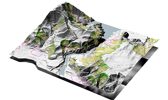
Shannon & Wilson’s study examined areas where slopes have failed in the past — an indicator of areas where slopes may fail again. To effectively examine more than 300 miles of largely uninhabited, heavily forested terrain, the team used remote sensing data — high-resolution LIDAR — to map landslide and debris flows. From the LIDAR, digital terrain models were created to examine certain features of these past flows.
The team was able to differentiate between different types of past flows — some more damaging than others. The team then divided the landslide susceptibility into high, moderate and low zones, and translated that information into a color-coded susceptibility map of the entire watershed area.
For the first time, Puget Sound Energy has a comprehensive inventory of the landslides and debris flow fans that potentially impact its facilities and operations. Additionally, Shannon & Wilson provided maps of most of the watershed areas where slopes are potentially susceptible to slope failure.
From these datasets and derivative products, Puget Sound Energy can target areas of concern, plan slope monitoring projects and incorporate landslide parameters in future remedial construction projects.
Other Stories: