|
Subscribe / Renew |
|
|
Contact Us |
|
| ► Subscribe to our Free Weekly Newsletter | |
| home | Welcome, sign in or click here to subscribe. | login |
Architecture & Engineering
| |
 |
October 27, 2011
Mapping a future for tidal energy
Golder Associates

Findley
|

Sylwester
|
The Snohomish Public Utility District is a Northwest leader in evaluating renewable and green energy resources. These resources generate power using technologies that rely on renewable fuel sources — such as wind, sunlight or plant matter — while having minimal impact on the environment.
Wind energy, mostly produced at sites in Eastern Washington, continues to be an important part of the region’s renewable resources; however, other promising forms of renewable energy exist in Western Washington. As a coastal state, we have a potential source of renewable energy in waves and tidal currents.
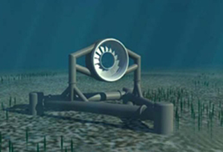
Snohomish PUD is evaluating the use of tidal energy as a renewable energy source. The PUD has studied seven locations in and around Puget Sound for tidal generators. These devices are similar to windmills but generate energy by using tidal currents to drive turbines located on the seabed.
Pilot project
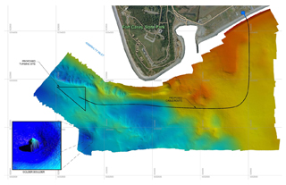
A site in Admiralty Inlet, just west of Camp Casey on Whidbey Island, has been selected for a pilot tidal energy project. Two turbines will be placed on the seabed in approximately 170 feet of water, and a subsea cable will transmit the resulting power to the grid on Whidbey Island. The pilot project will test the performance and potential for environmental impacts from tidal energy generation in the Puget Sound.
The PUD has been conducting pre-installation field studies in Admiralty Inlet with industry partners to support siting and licensing of the pilot project. These studies have included acoustic and water quality measurements, tidal current measurements, surveying for fish and marine mammals in the deployment area, and characterizing the complex seabed and subsurface geology at the site and along the cable corridor to shore.
The sea floor conditions at the turbine sites are the result of recent geologic processes.
The Puget Sound lowland has been covered by glaciers many times in the geologic past. The most recent glacier flowed from the north to cover the Admiralty Inlet area of Whidbey Island with up to 4,000 feet of ice about 17,500 years ago. During this period, sea levels were much lower than at present. The glacier cut off drainage through the Strait of Juan de Fuca and resulted in glacial lakes in portions of the Puget Sound lowland. When the glacier melted and retreated north it left recessional glacial sediments of variable depth that included thick layers of sand, gravel and clay. Sea levels rose and re-entered the Puget Sound lowland resulting in local deposits of glacial marine drift.
Examples of this recent geologic history are clearly seen in the bluffs around Whidbey Island.
Mapping it out
Golder Associates and its partner, TerraSond Ltd., were contracted to produce detailed maps of the complex bathymetry (underwater topography) of the seabed, and to map the geomorphology of the subsurface layers to a depth of 100 feet below the seabed.
Golder and TerraSond acquired data with a suite of instruments including a precision multi-beam bathymetric system, a high-resolution side-scan sonar, and high-resolution sub-bottom and seismic reflection systems. The bathymetric and side-scan sonar data showed the complex nature of the seafloor that was formed by continental glaciers and modified by tidal currents.
The most interesting features that Golder and TerraSond mapped were the large glacial erratics (boulders) resting on the seabed. Glacial erratics are not unusual on land, but this is the first time they have been identified on the floor of Puget Sound. A number of the erratics mapped on the seabed have dimensions of about 12 feet by 10 feet by 4 feet, and weigh approximately 35 tons.
The largest boulder is 55 feet by 30 feet by 20 feet, and is estimated to weigh as much as 3,000 tons.
It is surprising that these boulders, which were probably deposited over 12,000 years ago, have not sunk into the seafloor. This suggests that the underlying glacial material is extremely dense and could provide a solid platform for the tidal turbine generators that weigh 100 to 200 tons.
Dave Findley, LG, LEG, a senior engineering geologist with Golder, has been working with the glacial geology of the Puget Sound lowland for over 30 years. He also has conducted terrestrial and offshore marine investigations in support of infrastructure projects around the world. Dick Sylwester, LG, LEG, a senior marine geophysicist with Golder, has a degree in geologic oceanography and engineering geophysics from the University of Washington. He has been mapping offshore geology in Puget Sound and throughout the world for over 40 years.
Other Stories:
- McGuire misfortune spurs building code changes
- Economy has A/E firms tightening their belts
- Architects become ‘master of ceremonies’
- Is your LEED project a green hornet’s nest?
- Carbon-fiber arches raise the bar for bridge design
- Many older buildings not ready for the big one
- Modern work spaces bring out the best in employees
- Tudor Gothic facade hides modern interior of UPS Hall
- Seattle U apartment spawns woonerf, pocket park


