|
Subscribe / Renew |
|
|
Contact Us |
|
| ► Subscribe to our Free Weekly Newsletter | |
| home | Welcome, sign in or click here to subscribe. | login |
Construction
| |
 |
January 25, 2016
Best in state: Gold award
Future value to engineering profession
GeoEngineers

Project: Kentch Reach habitat restoration and floodplain reconnection
Client: Confederated Tribes of the Umatilla Indian Reservation
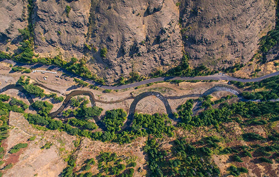
In the late 19th and early 20th centuries, logging and agricultural practices along the Kentch Reach on the South Fork of the Walla Walla River virtually eliminated native fish spawning and juvenile rearing habitat for more than 100 years.
The Confederated Tribes of the Umatilla Indian Reservation purchased the site in 2003 to restore fish and wildlife habitat. The tribe’s vision was to allow the river to once again meander back and forth across its original floodplain.
To realize this dream, the project team needed to focus not just on building habitat, but also on rebuilding the river’s original physical processes.
But with no historical reference point to draw on, the team used cutting-edge analytical and quantitative methods to re-imagine the intricate processes that existed before humans intervened. The team predicted natural conditions at the reach using several methods that quantified discharge, slope, width, depth, panform, bed-material size and riparian conditions.
A GeoEngineers-developed software tool call HOME (Habitat Optimization Modeling of Ecosystems) combined hydraulic modeling and quantitative habitat data to visualize how individual restoration features influence habitat improvements. This software helped visualize how habitat conditions would change for specific species, life history stages and seasonal flows.
Projects of this type do not commonly include groundwater studies, but the scale of this restoration required extensive revegetation along the new alignment, and there was concern that the record dry conditions would limit plant growth. So GeoEngineers conducted a groundwater study to determine planting depths required to reach the water table, plus to estimate hyporheic (mix of shallow groundwater and surface water) interactions. Thanks to this additional step, nearly 100 percent of the new plantings survived.
Traditional restoration approaches lock the channel in place and create static environments that need to be maintained when the river adjusts to changing conditions. GeoEngineers’ design allows the river to respond and adjust to events such as flood and debris accumulation in a manner that shapes and maintains improved habitat conditions over the long term.
The project reclaimed and restored 47 acres of floodplain, increased the channel length from about 3,500 feet to 4,300 feet, increased side channel length from about 160 feet to 3,500 feet, and roughly doubled available habitat. It also protected a critical hatchery program during construction by limiting turbidity, matching construction with the fish-treatment schedule and designing a silt fence at the hatchery intake.
Mike Lambert, project manager from the tribes, wrote to GeoEngineers: “Given the sediment concerns, risks endured at the hatchery facility, concerns of impacts to irrigators, … and all the project logistics including budget, contracting needs and changes, design addenda, sediment control planning, construction oversight and management, you completed the Kentch Project in a technically sound manner and on schedule.”
Other Stories:
- National finalist: Platinum award
Structural systems
T.Y. Lin International - National finalist: Gold award
Energy
DLR Group - National finalist: Gold award
Structural systems
HNTB - National finalist: Gold award
Waste and stormwater
Parametrix - National finalist: Gold award
Water resources
Parametrix - Best in state: Gold award
Unique or innovative applications
DCI Engineers - Best in state: Gold award
Successful fulfillment of client/owner needs
Osborn Consulting - Best in state: Gold award
Social, economic and sustainable design
Otak - Best in state: Gold award/Special judges award
Complexity
KPFF Consulting Engineers


